Queensway, Hong Kong
What I knew of Hong Kong before I moved here came from film and photography. It was a dense, post-modern city that in earlier decades had been characterised by its economic success. Since the turn of the century, the city has been pummelled by shocks and anxieties. Life in Hong Kong was uncertain and its people were resilient. Its architecture – of public housing blocks, colonial fragments, and corporate towers – mirrored a culture always on the verge of its own disappearance. In a cab from the airport, the city’s towers appear as tall as its hills. The view of Hong Kong Island from Lantau opens to the south, the sea of buildings flattened to form an impossible topography, their profiles compressed in a superposition of skylines that climb the elevation until the dark of the hillside escapes upwards. Meanwhile, other solitary towers can be measured with lines pulled from their tips to the tall peaks. There is something improbable about the city. How it came to be in this scraggly, pinched landscape, with earth dredged from the ocean, and the shore pushed back into the sea, is a history of extractive colonial forces that continues unceasingly. These forces converged into a narrative of a global city that calls forth an interiorised, endless space of shopping malls, corridors, elevated passages, and shopping arcades: a smooth continuity that connects home and work in the creation of pliant subjectivities.
But this description of Hong Kong is inadequate, itself too smooth and totalising. Instead the city offers multiple planes of exchange and the ground is an important site for contestation. By ground, I mean plazas, squares, country parks, no man’s lands under highways, streets, and sidewalks. These are domains of urban life that function in opposition to the regulated world of the interior. If the ground is hard to locate, this has as much to do with neglect as it does with effacement. If it has ceased to be the site of much care or attention it is due to the patchwork of administrative entities that maintain any one part. Developers are responsible for the sidewalks fronting their towers, meaning that the quality of this public way is left to the generosity and design attention of a builder’s architects and the budgets at their disposal. The result reflects the status of the adjacent tower rather than any coherent or shared commitment to the public realm. In a city famous for the value of its real estate, what is shared between residents as a common is given little meaningful attention considering the crucial role that it plays in domestic realities characterised by cramped homes. [1] In that sense, the ground is a public home.
In his introduction to Streets for People (1969), Bernard Rudofsky argued that architects could be blamed for the neglect of the street because they represented it as the leftover white space between two lines. More than two decades later, On Streets (1986), a collection of essays edited by Stanford Anderson, included a bibliography of references classed under: ‘Streets: Notation Systems, Representation’. These sources comprise publications with traffic and pedestrian diagrams, analysis done with aerial photos, and mapping. [2] While these modes of making drawings did little to address Rudofsky’s earlier complaint, mapping has perhaps transformed how we draw cities. Geo-localised data sets and cartographic imaginations make it possible to ‘look close from a distance’ so that today the ‘agency’ of mapping lies in its capacity to ‘engender the re-shaping of worlds’ by the ‘uncovering of realities previously unseen or unimagined even across seemingly exhausted grounds’. [3]
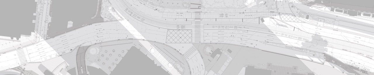
Yet the very qualities that make mapping a potent scripter, make it less apt for looking at the street as a constellation of material and tectonic assemblages. With Queensway/Hong Kong, I wanted to draw the street ‘as it is’: to create an analogue of the cracks, elements, markings, and slopes that describe its disarray. Drawing ‘as it is’ – limited to visible, measured attributes and bound by architectural norms – nevertheless entails a process of abstraction that can be revelatory, sharpening one’s vision. Because our habit of inattention leads to a lazy imagination of the street as an undifferentiated surface, drawing in this way demanded a new method for seeing. [4]
Photographs, films, and note-taking on a cadastral map acted as an initial recording. Returning on multiple occasions with folded printouts in hand, made it possible to annotate, measure, re-photograph and re-draw. The drawing became a record of a 1:1 relationship: walking the street coordinated with notes on the page. A mediated looking – through photographs, sketches, notes and Google Street view – and the directness of live observation entered into a constant, sometimes unreconcilable tension. The decisions that are a product of that tension immediately reveal the street to itself be a negotiated and contingent relational production. Rather than a blank surface, the street is a multiplicity of dispersed material and coordinate assemblages: decisions built up over time.
The sensibility engendered by this attention opened a curiosity to drawings from the past. The most influential of these is a pair with Pierre Patte’s well-known section for an ideal city which appears in Mémoires sur les objets les plus importans de l’architecture (1769). Patte’s section describes subterranean infrastructural voids that regulate the movement of flows. [5] His drawing contributed to the machinic and anthropomorphic cast that frames how we speak about urban infrastructure. [6] The section appeared at a moment when the functioning of the city was being reconceived as a problem for technical management. In Portugal, after the great earthquake of 1755, engineers used the street section to demonstrate advances that could spare Lisbon from renewed destruction. [7] The street section also entered popular culture, with French illustrations depicting correspondences between social and spatial strata: the wet street outside contrasting with bawdy crowds in small interior rooms. [8] The street section rendered the hidden city visible by revealing its technical and social organisation. [9]
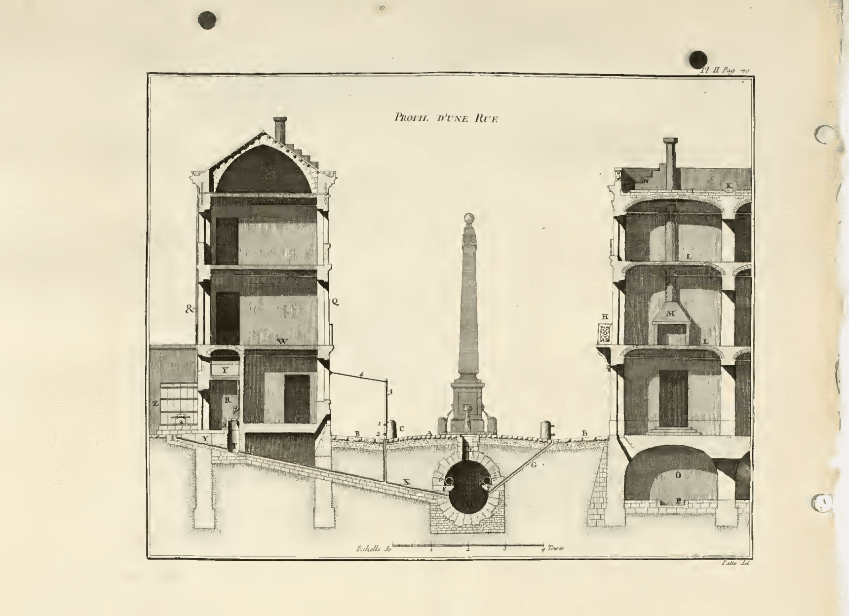
Patte’s celebrated contribution to urban representation often ends with his famous section. While it was familiar to me, the double-page plan that accompanies the section was not. This plan shows two intersections in the new city. Accompanied by a graphic scale, the drawing comprises an oblong section of road that measures approximately 31 x 13 pied [9.8m x 4.2m]. This stretch begins at a quay and continues to intersect a road of larger width. The linear proportion of the drawing makes it difficult to grasp the entire image at once. Letters – referenced in Patte’s text – are stamped onto the plan and correspond to labels on the section, suggesting that the two drawings are meant to be read together.
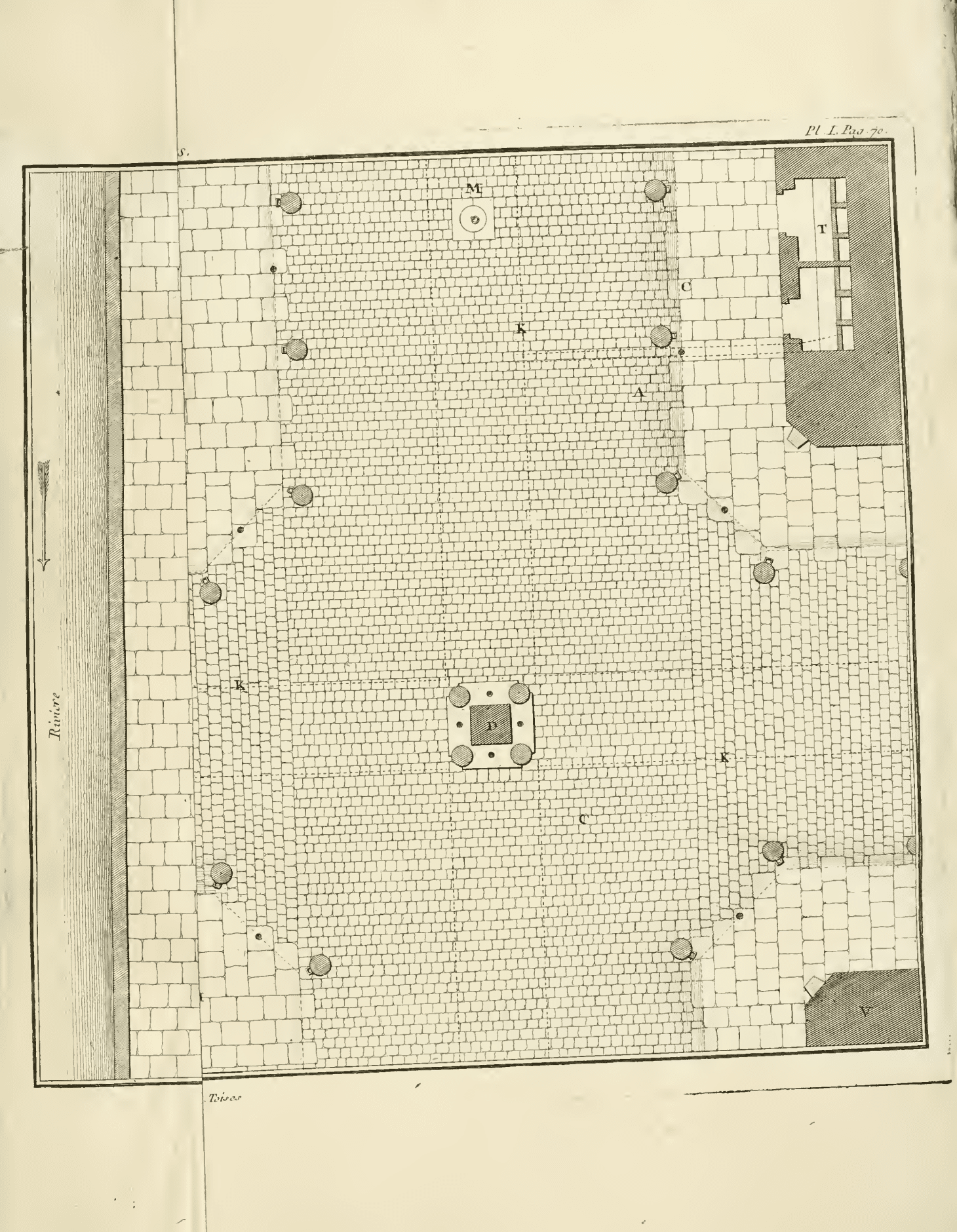
The street’s functioning in the plan is indicated by small ruptures in the surface: holes to collect water, covered pits for the deposit of household waste every morning. The plan also masks the obliques that are integral to Patte’s system. The running of water along surfaces is instead implied through indices: a hatch parallel to the shallow crease where the sidewalk and the street meet, or dotted lines for the underground sewers and for the narrow household pipes that feed into it. Where the section is syncopated by voids connected across space – each linear conduit filled with the echoing sound of its functioning – the plan is silent. Where the section manages linkages between domestic and urban infrastructures, flattening space as an instant of time, the plan speaks of a temporality outside of a well-functioning network of parts. The topological smoothness of the plan corresponds to the surface of the street itself. As a drawing it is coincident with lived experience and the time of movement along its plane.
Making the street a subject required a way of looking that did not turn to diagrammatic abstraction. The professional diagnosticians who have taken charge of much of the urban realm work in representations that cast the street as a smooth conduit, regulated by various techniques of control. The parallel lines that contain its space are articulated with signs and symbols and then configured to produce scenarios that have been studied, calibrated, and modelled. Yet through this technical mastery, streets become empty surfaces unable to account or make space for lives that will take place there. Queensway/Hong Kong attempts to describe the ground as a site of different forms of relations. From the west, the HSBC Building and the old Bank of China Tower, barricades remaining from days of protest. Chater Garden – the old cricket grounds – where migrant domestic workers gather on Sundays. Aerial wires that power the tram line snake along Hong Kong Island’s southern edge, sometimes along land that was its former coastline. New lampposts fixed with cameras. Plants in medians under overpasses, not far from the shade of wide canopied bauhinia trees planted long before. And incisions, displacements and erasures that describe the making and remaking of a ground that is less a surface than a momentary entanglement of agencies caught underfoot.
Sony Devabhaktuni’s Curb-scale Hong Kong: Infrastructures of the Street (Applied Research + Design Publishing) will appear in early 2023.
This text was submitted to the General Autograph category of the Drawing Matter Writing Prize 2021.
Notes
- In her study of sidewalk culture in Ho Chi Minh, Annette Kim points out that a city’s sidewalk system often exceeds the area of its parks and open spaces and are increasingly important for diverse groups of residents for whom these strips of open space are the most accessible urban commons. See: Annette Miae Kim, Sidewalk City: Remapping Public Space in Ho Chi Minh City (Chicago: University of Chicago Press, 2015).
- Stanford Anderson (ed.), On streets, (Cambridge, Mass: MIT Press, 1986), p.399.
- James Corner, ‘The Agency of Mapping: Speculation, Critique and Invention’, in The Map Reader: Theories of Mapping Practice and Cartographic Representation, eds. Martin Dodge, Rob Kitchen and Chris Perkins (Chichester, UK: John Wiley & Sons, 2011), p.213. On the use of aerial visioning technologies, see: Laura Kurgan, Close Up at a Distance: Mapping, Technology, and Politics (Brooklyn, NY: Zone Books, 2013).
- The geographer Doreen Massey argues that our spatial imaginations are limited by the notions of surface and horizontality. She proposes instead that space is an entanglement of multiple trajectories that meet in a relational production. See: Doreen B. Massey, For Space (London: Sage, 2005).
- See Antoine Picon’s chapter on Patte and his contribution to the planning of cities: Antoine Picon, French Architects and Engineers in the Age of Enlightenment (Cambridge: Cambridge University Press, 1992), pp.186-210.
- Andrew J. Tallon, ‘The Portuguese Precedent for Pierre Patte’s Street Section’, Journal of the Society of Architectural Historians 63, no. 3 (2004), https://doi.org/10.2307/4127976.
- For a study of these illustrations, See: Diana Periton, ‘The “Coupe Anatomique”: sections through the nineteenth century Parisian apartment block’, Journal of Architecture 22, no. 5 (2017): 948n52, https://doi.org/10.1080/13602365.2017.1351805. & Emily Eastgate Brink and William M. Taylor, ‘Architecture and Crowd-Less Streets: Urban and Environmental Order, Absence, and Risk in Pierre Patte’s Profil d’une rue (1769)’, Architectural Theory Review 23, no. 2 (2019): p.179, https://doi.org/10.1080/13264826.2019.1656267.
- Patte’s work on theatre design would perhaps also have made him aware of sectional interior representations. For example, Charles-Nicolas Cohin’s Projet d’une salle de spectacle pour un théâtre de comédie (1765), includes sections that reveal the social classes stratified within the spaces of the auditorium – each within their own small rooms – and a lateral cut through the stage that shows the void underneath it. For a description of Patte’s work on theater design, see: Pannill Camp, ‘Le coup d’il du spectateur: Spectatorial Function and Stage Space in French Theatre Design, 1760-1784’, Journal for Eighteenth-century Studies 32, no. 4 (2009), https://doi.org/10.1111/j.1754-0208.2009.00223.x.
- Picon includes the plan alongside the section in his chapter on Patte but does not offer any comments. Picon, French Architects and Engineers in the Age of Enlightenment, p.199. Eric Alonzo also includes both plan and section in his comprehensive study of the architecture of roads, and describes details that reflect a concern for circulation, see: Éric Alonzo, L’architecture de la voie : histoire et théories (Marseille: Parentheses, 2018).
