DMJ – From Landscape to Mapscape: Robert Smithson’s Maps
This text, published alongside Jonathan Foote’s article ‘Borromini’s Smudge’, marks the launch of the first and second issues of DMJournal–Architecture and Representation. Over the coming months, we will be publishing articles from both DMJ 1: The Geological Imagination and DMJ 2: Drawing Instruments/Instrumental Drawings. The Geological Imagination will be published in print in early 2023.
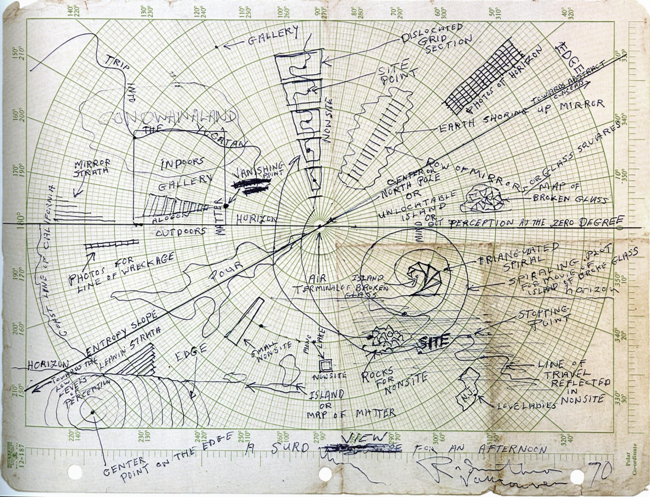
Robert Smithson, A Surd View For An Afternoon, 1969 (signed 1970). Ink, 21.6 x 27.9 cm. Holt/Smithson Foundation. (From: Robert Smithson, Spiral Jetty. True Fictions, False Realities, ed. by Lynne Cooke and Karen Kelly, Berkeley, Los Angeles, London: University of California Press, 2005, p. 93). © Holt-Smithson Foundation ARS, NY and DACS, London 2022.
The maps by Robert Smithson paved the way for a conception of ‘geo-media’ that goes beyond familiar media of representation. Maps were not only a frequent component of the artist’s works – first of all of his nonsites – but the ‘map’ was also a key concept that informed his work from 1966 onwards. Smithson’s maps do not intend to represent a territory; they are not a cultural technique of navigation in the usual sense. Instead, they act as geo-media in the sense that they open an exploration of the limits at which signifiers and matter become indeterminate.
While working as a consultant for an architecture firm in 1966/67 on a project for the Dallas–Fort Worth airport, Texas, Smithson became acquainted with the professional use of maps and charts of all sorts (plans, aerial views, land surveys) that prompted him to call for a new type of art, which he called ‘aerial art’. Aerial photography, which makes the world look like a three-dimensional map, allowed him to interlock the macroscopic with the microscopic, the cartographic grid of latitudes and longitudes with the inner structure of crystals: as he observed, ‘maps resemble crystalline grid networks’. The transition from map to territory, from writing to matter, in this case was achieved by the operation of scaling. However, in the nonsites, which grew out of his work on the airport project, the operation of scaling was replaced by practices of collecting, transportation and travelling, which allow the nonsite to become ‘a kind of deep three-dimensional abstract map’ in which a part of what it represents is present.
If the operations of scaling, on the one hand, and travelling and ‘getting nowhere’, on the other, interlock diagrammatic writing and matter (or what in Lacanian terms could be called the Symbolic and the Real), then a third operation, which I call ‘Smithson’s basic operation’, produces the transition between the map (as a site that allows for the incorporation of the Real into the Symbolic) and the Imaginary. The key to this operation is Smithson’s use of polar co-ordinates, which has been almost completely overlooked by art historians. Polar co-ordinates make possible the convergence between central perspective (which, since Brunelleschi and Alberti, has stood for the ‘true’ projection of the three-dimensional world on to a two-dimensional plane) and cartography. The form of a cell of a polar co-ordinate system coincides with the form of a basic unit of the perspectival grid, which consists of orthogonal and transversal lines. It is important, though, that this relation does not negate the difference between the two systems for representing space – perspective and cartography – but rather produces an uneasy alliance, or what Smithson calls a ‘dialectic’, which is however non-Hegelian as it knows no sublation. This third operation is used by Smithson in order to translate linear perspective and geology into each other. Pieces like Gyrostasis or Leaning Strata (1968) develop from cartographic constructions that open perception on to geologic deep time.
Smithson’s three map-related operations can be used as the framework for a concept of geo-media, which anticipated essential ideas of the environmental (or elemental) turn in media theory (Jennifer Gabrys, Jussi Parikka, John Durham Peters, and others), and may contribute to the further development of the theory of cultural techniques as well as to that of media ecology.
DMJournal–Architecture and Representation
No. 1: The Geological Imagination
Edited by Mark Dorrian and Kurt Forster
ISSN 2753-5010 (Online)
ISBN (forthcoming)
About the author
Bernhard Siegert, Ph.D, is Gerd Bucerius Professor for History and Theory of Cultural Techniques at the Media Faculty at Bauhaus University Weimar. From 2008 to 2020 he was co-director of the International Research Center for Cultural Techniques and Media Philosophy at Weimar (IKKM). Since 2021 he has led the project ‘THE NEW REAL – Past, Present, and Future of Computation and the Ecologization of Cultural Techniques’ funded by the NOMIS Foundation.
Siegert was awarded visiting professorships and fellowships (among others) at UC Santa Barbara, New York University, University of British Columbia, and Harvard University. Among his more recent book publications is Cultural Techniques: Grids, Filters, Doors, and Other Articulations of the Real, translated by Geoffrey Winthrop-Young (New York: Fordham University Press, 2015).
Click here to receive updates about the journal, and future calls for abstracts.