The Right to Imagine: Michael Sorkin’s Visual Argument
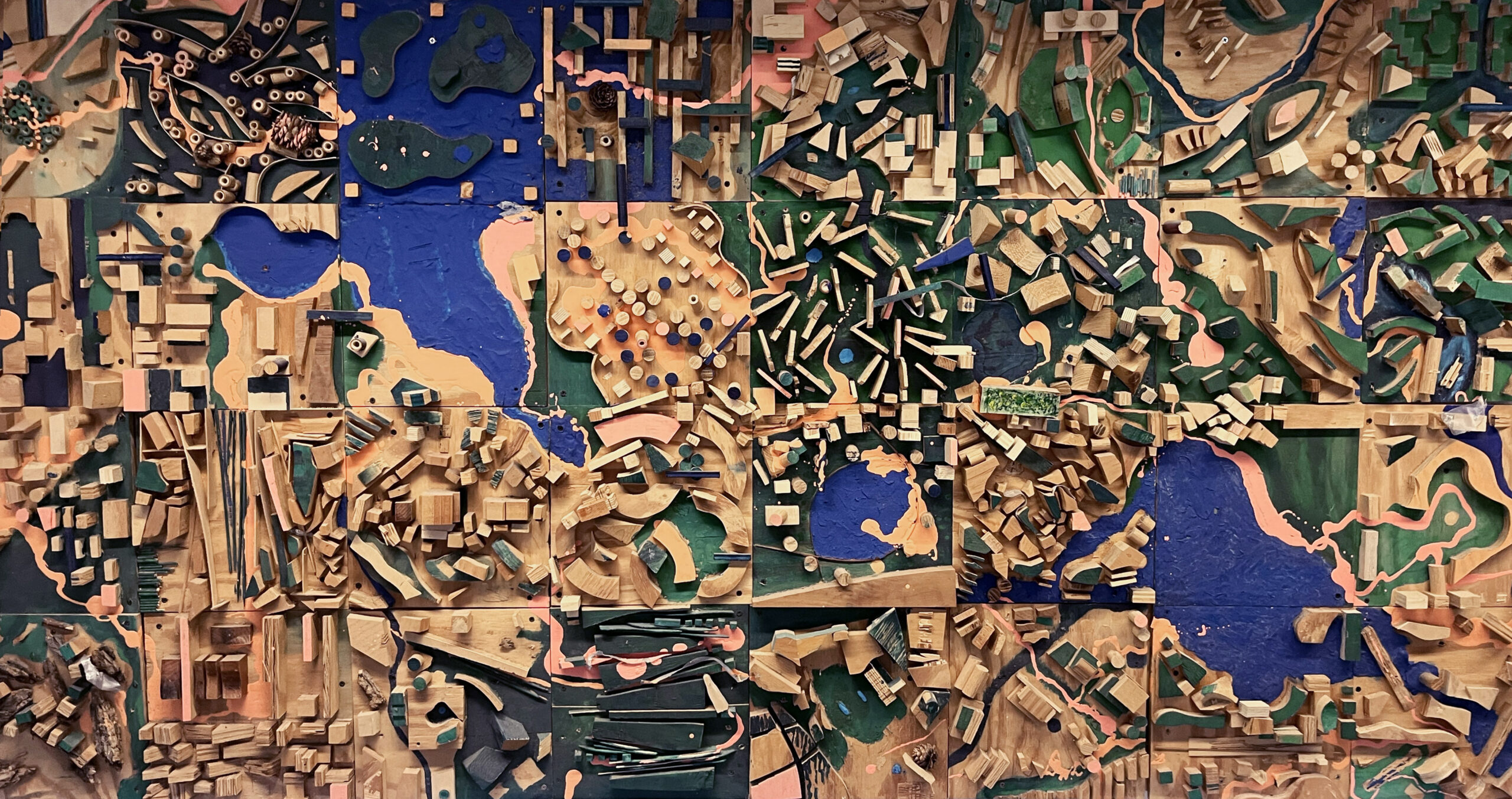
On the wall of the third-floor mezzanine of the Spitzer School of Architecture of The City College of New York (CCNY) hangs a wood model titled Urbanagram. It was the product of a collaboration of students of the Master’s in Urban Design Program, directed for almost two decades by Michael Sorkin (1948–2020). The work is an assemblage of models produced by multiple students, following a few common directions. The methodology was inspired by the surrealist entertainment called Exquisite Corpse, which is also the title of one of Sorkin’s books. Andre Breton describes it as ‘a game of folded paper played by several people who compose a sentence or a drawing without anyone seeing the preceding collaboration or collaborations […] we had at our command an infallible way of holding the critical intellect in abeyance and of fully liberating the mind’s metaphorical activity.’[1] In Sorkin’s view, like the Exquisite Corpse, ‘cities are made by many players, with varying degrees of autonomy, within a complicit framework.’ A sense of order is set by the creation of certain rules that regulate the scope of individual invention. The size of the sheet of paper and the sequence of its folding—in the case of the game—politics, planning, economics, history, and culture, in the case of the city.[2]
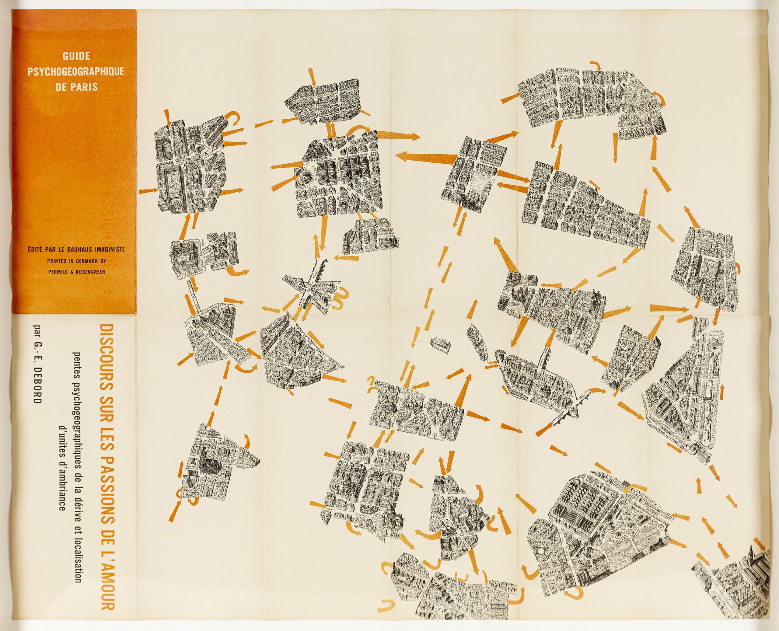
The establishment of Urban Design as a graduate program in the United States in the late 1950s marked a disciplinary convergence of fields that, in many countries, were gradually being segregated as either architecture or urbanism. Michael Sorkin sought to preserve the unity of these two domains.[3] Through various media of expression, he pioneered the conception of urban agendas that have come to define the practical and theoretical environment of design disciplines in the United States over the last two decades. Sorkin’s studio journey, while teaching and directing the Graduate Program in Urban Design of The City College of New York, often started with the reading of Guy Debord’s Theory of the Drift, or Dérive. Premised on the conviction that being lost is essential to original, creative discovery, much of the vibrancy of Sorkin’s contribution was a matter of presence. Stories, tales, and quotidian practices created the ambiance of studio work.
Since the 1980s, the directions of the Exquisite Corpse exercise have evolved, but some foundational parameters have been employed consistently. A set of initial directives is given to students:
‘the area of the model is 150 square feet; the material is wood; the shape is squarish (the shape of pieces is undetermined); a plywood base should be understood to be grade.’ A few more operations are then prescribed: ‘the model is divided into 2X (x=number of students) pieces and a Tectonic Vector; the pieces are of two types: Sites and Nabes; they are to be approximately equal in area and may be of any shape but may not exceed one square meter; sites may not adjoin. The Tectonic Vector (TV) is an additional element or area where no construction is permitted (of up to 15% the area of the city).’
It is continuous in form, as a void, that touches each of the Nabes (Sorkin’s word for ‘neighbourhood’ in the assignment). ‘What it is (mountain, minefield, river, zone of altered consciousness, etc.) is not, for the moment clear.’ A few more directions are given to regulate heights and density, and are subsequently complemented by exercises not initially disclosed, called ‘enhancements’.
Curiously, a letter addressed to Sorkin in 1992, signed by Bernard Tschumi (then Dean of Columbia University’s Graduate School of Architecture Planning and Preservation) with the note ‘cc: Kenneth Frampton’ at the bottom, states the following: ‘We would like you to articulate your studio project in such a way that the work of students can be presented individually (models and drawings), as opposed to previous semesters where one large “communal” construction became the ultimate goal of the studio.’[4] Sorkin’s pedagogic strategy aligns with the ethics of city-making he promoted in his writing, situating his academic work as another mode of activism.
Much of what has recently been discussed in the fields of architecture and urban design gravitates towards generating more inclusive systems of exchange and facilitating convergence among various civic groups and formal city governance. This can be understood as a compensation for, or overcoming of, the gradual distancing of architecture from its political dimension, which established a sharp polarisation between professional practice and its social function in the second half of the twentieth century in the United States.
As the debates about the social responsibility of professional practice and the search for an ethical and political meaning in design intensified, the role of drawings in architectural culture seems to have gradually lost protagonism. Architectural imagination through tangible, projective visualisations is often displaced to a secondary role. In some contexts, this process resulted in a gradual technical and aesthetic weakening, which can be recognised in community, or ‘engaged’, projects that often operate at a reduced ‘minimum possible’. Paradoxically, this leads to a further suppression of the experimental and critical dimensions of the design disciplines.
The composition of drawing fields (whether two-dimensional or three-dimensional visualisations) is central to our interpretation and transformation of the urban environment. They reconcile and potentially integrate complex and divergent desires from multiple stakeholders. Neil Brenner introduces the term ‘counter-visualizations’ to define representations that seek to dissolve urban ideologies and question prevailing paradigms and hierarchies. According to Brenner, Counter-visualizations are meant to destabilise the hegemonic structures of globalised urban ideology and can be understood as a critical work aimed at opening new horizons for the imagination of emerging patterns and paths of urbanisation across the diverse geographies of our planet.[5] Socio-spatial hierarchies, often underlying and implicit, taken for granted and unquestioned, tend to reiterate dynamics of power and exclusion. Brenner views the dissolution of visual orders on both territorial and architectural scales as a project of representation, arguing that drawings can be a critical tool to inform contemporary city-making.
In the field of cartographic representation, a few theoretical investigations at the turn of the twentieth century pointed to a movement towards a ‘general politics of spatiality’ and to the cultural study of literary, artistic, and ideological forms of mapping.[6] One of the most important dimensions of cartography, argues Bruno Bosteels, lies in its capacity to order existential territories and reveal these worlds over the irregular surface of the earth. According to Bosteels, cartography should explain the multiple articulations of the social and the subjective and seek models capable of revealing how ‘desire and production, madness and work,’ may intersect in the territory.[7] In his view, the cartographic project is an undoing of a stabilised social through the legibility of (yet to be revealed) relations identified in a two-dimensional representation. ‘A map, then, is never just a mirror of nature. It is neither an adequate imitation nor a transparent reflection of a stable territory already existing elsewhere.’[8]
This approach, originally more widespread in the fields of literary criticism and philosophy, has become common knowledge among cartographic theorists and historians. As a cartographer, the urban designer acts in the representational field on the threshold between scientific registers and fiction, as an interpretive actor destined to engage subjectively with their historical present. Charles Waldheim presented a viewpoint similar to Bosteels’ in Aerial Representation and the Recovery of Landscape (1999), explaining the relationship between landscape design and landscape representation as one of co-dependency: ‘The world is visually prefabricated through its potential for being seen. Perhaps even more than in any other field or cultural endeavor, the picturing of the landscape has become synonymous with the discipline itself, as if landscape only existed through its picturing.’[9] According to Waldheim, with the advent of aerial photography, the scenic and pictorial images were replaced by the perception of a vast, managed surface. It established a reference for what was previously unattainable. Aerial photography inaugurated a new era of imagining the surface of the world, which changed the meaning and status of the practice of landscape drawing. Waldheim uses the term aerial subjectivity to explain this shift enabled by photography, which differed from the use of metric cartographic references at the time.[10]
These authors argue for the importance of representation in formulating new cultural imaginaries and its potential to bridge the fields of architecture, visual arts, politics, and literature. Critical drawing, as the starting point of the design process, implies that reality is not understood ‘a priori’ but rather visually deconstructed.
Ground Zero
In the 60s, 70s and 80s, a series of radical architectural languages emerged in the context of the United States and Europe. The work of Cedric Prize, Archigram, Yona Friedman, Archizoom, Site, Lebbeus Woods and Superstudio, among others, opened new inquisitive potentials for design. They formulated architectural and urban visions that radically challenged mainstream post-war modernism. The work of Michael Sorkin, especially during the last three decades of the 20th century, could be placed alongside this current. Yet Sorkin’s intensified political project, manifested through pedagogy, writing and practice, underpinned by an aesthetic commitment to subjectivity and the expression of cultural identity, positions him at a unique, distinguished gateway to contemporary practices. Fiction and fantasy in his work maintain proximity to the social and material exigencies of city-making. Consequently, his oeuvre functions as a critical locus where the visual and the political, the subjective and the collective, converge. His proposals for Ground Zero in New York City offer us a clear example of these approximations.
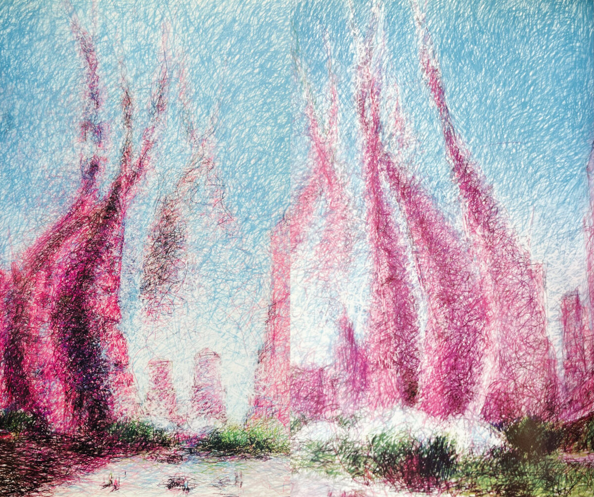
A series of drawings, diagrams and texts developed between 2001 and 2003 was assembled in the book Starting from Zero: Reconstructing Downtown New York (2003). Various techniques build a diverse representation lexicon, which alternates in the employment of digital and analogue tools. They include photographic collages, sketches, aerial perspectives, plans, sections, and ground perspectives. The Lotus is one of Sorkin’s iterations for the reconstruction of Ground Zero. In it, a sequence of visual representations is intermingled with articles published in various forms of media between 2001 and 2003. The occurrence of the 9/11 attack on the Twin Towers (2001) in New York City opened an opportunity for reimagining another form of urbanity in that area. The Lotus can be understood as an evolution from First Response, one of Sorkin’s earliest visualisations for the future of the site.
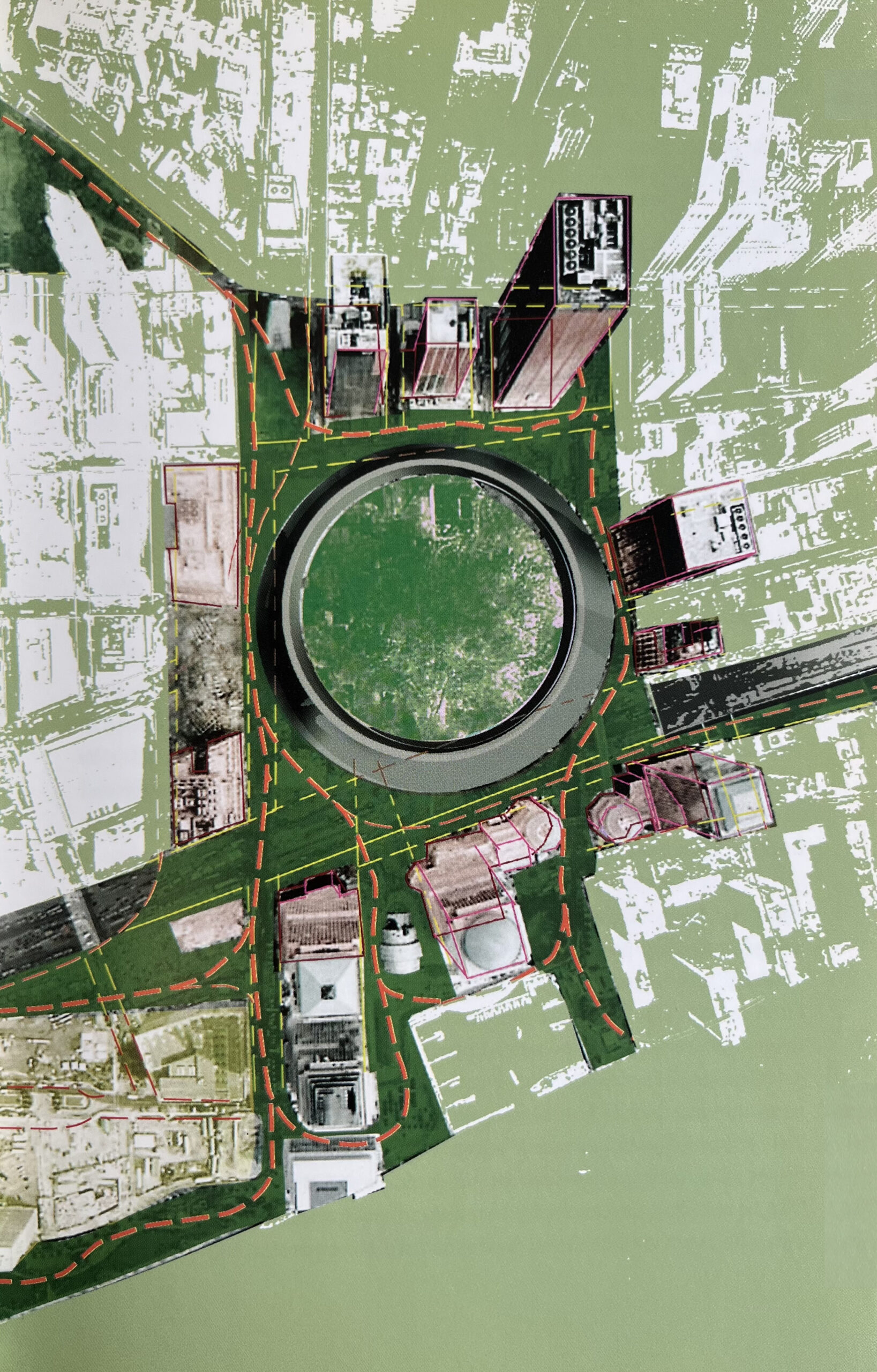
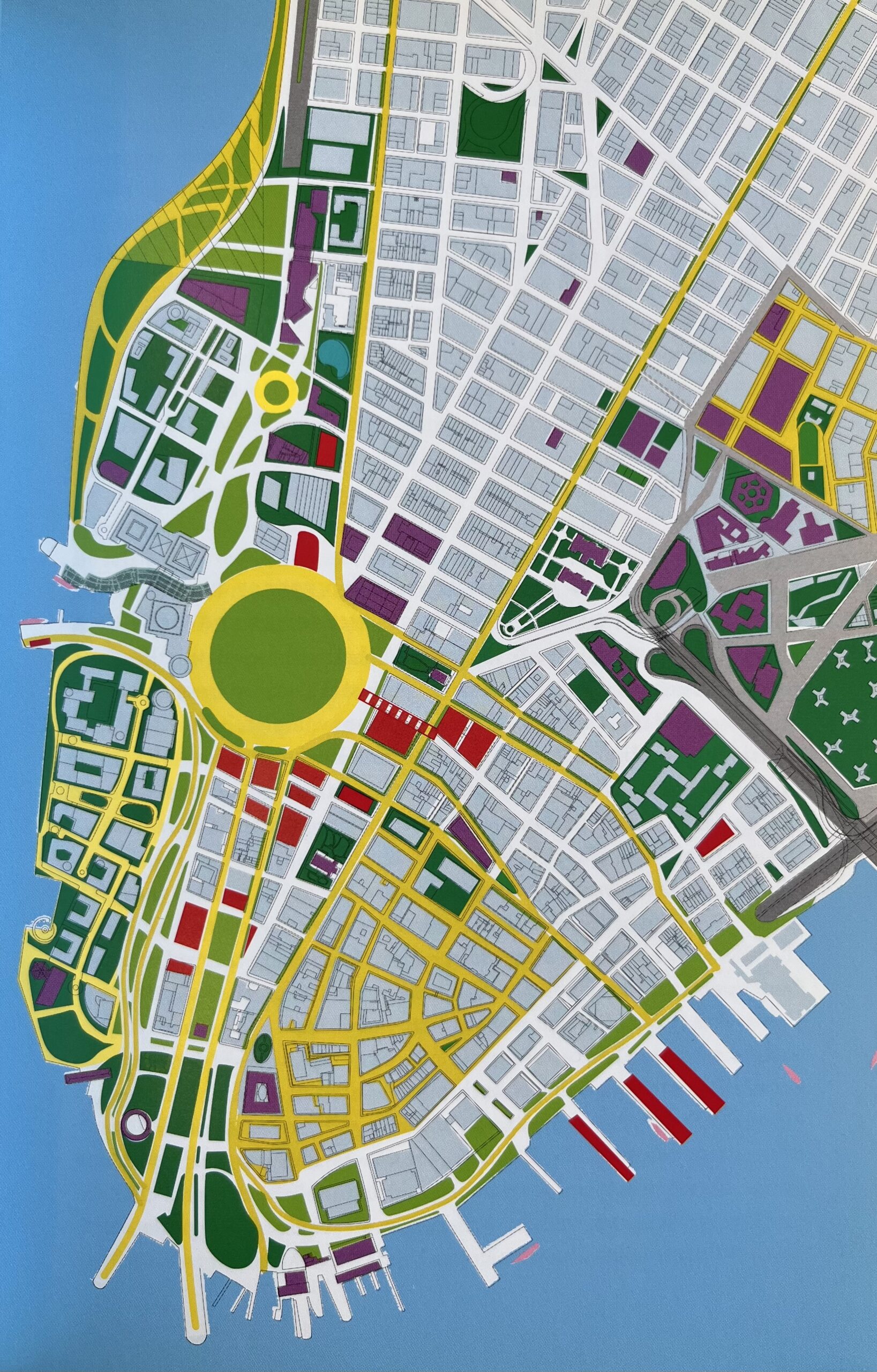
First Response delineates an open circular spacethe total clearing of the site. Memory is expressed as emptiness. The void holds the potential for conviviality and new forms of social exchange. It radically turns its back on corporate footprints, as it doesn’t include any commercial space to replace what was on the site prior to the tragedy. A counter-visualization, in Brenner’s term, the dissolution of the established urban orders of lower Manhattan is further explained through Sorkin’s new masterplan. In this plan, we see the circular void as the articulator of a network of new public green spaces. The viability of the proposals was backed up by a tangible step-by-step roadmap for the reconstruction of the city. He enforces the coexistence of ‘expressive singularities,’ which should be envisioned as semi-autonomous instead of ancillary.[11] Sorkin intended for this new network of spaces to alleviate the density of the existing vertical city, which took shape from an 18th-century Dutch medieval grid.
The Lotus, arguably Sorkin’s most radical visualisation for the future of the site, is also conciliatory. The formal answer is more than a provocation: it can be interpreted literally as a strategy. It proposes the convergence of the central void-memorial with vertical towers that could respond to real estate pressures on the site. The gestural, sinuous, colourful expression of the proposal is dressed in ambiguity. The buildings’ silhouettes dissolve towards the sky, skewing and collapsing a traditional understanding of the vertical. In doing that, Sorkin both adheres and contests. He reinforces the vision of a city composed of individual imaginaries, of particular identities, subjectivities, and expressions. Sorkin employs radical form to reinforce the emergence of a vibrant, non-neutral city—an existential territory, in Bosteels’ terms. The representations combine the precision of lower Manhattan’s grid with an open-ended, uncontrolled building mass.
The intensification of the subjective seen in these drawings also aligns with Sorkin’s critique of smart-cities. The role of technology and the manipulation of information about individuals and their behaviour in the city was a central concern to him in the 2000s. In his view, the obscure performance of a ‘big brother’—his reference to Google—replaced the possibility of a technology ‘socially produced’ in the daily life of the cities. He attacked the concept of smart cities, appealing to what he called the wise city,[12] as a resistance to technologically driven, anonymous corporate urban models. In his words, ‘the truly wise city must begin with a deep appreciation of its immemorial, individual, fundamentals, with the specifics of its cultural and bio-climatic situations and look critically to technology to reinforce and extend them.’[13]
The proposals for the reconstruction of Ground Zero and lower Manhattan were developed while Sorkin published texts in mainstream media. The Ground Zero visualisations were used as a tool to engage with multiple stakeholders following the tragedy and to propel discussions that could prioritise shared spatialities and collective agendas in a city historically entrenched by private investments. Sorkin reveals subjacent relations within the urban fabric that may reconcile the city’s past (the 9/11 tragedy and its 18th-century grid) towards a new model of growth and prosperity, centred on pedestrian life and the possibility of social encounter.More than merely provocative or open-ended, his drawings reconciled formal anxieties with political purpose, teaching generations of urban designers, theorists, and educators that citizenship can only be exercised in these fields through the pairing of inquisitive, critical thinking with spatial imagination. As he often noted, the right to the city is predicated upon the right to imagine the city.[14]
Notes
- Michael Sorkin, ‘Carleton University Winter 1994 Studio 4b Brief,’ Michael Sorkin Reading Room Archive, Spitzer School of Architecture, City College of New York.
- Ibid.
- Michael Sorkin, Exquisite Corpse: Writing on Buildings (London: Verso, 1991).
- Michael Sorkin, Letter, Folder ‘Columbia University GSAPP 1992,’ Michael Sorkin Reading Room Archive. The collective methodology of Sorkin’s pedagogy was challenged with the explanation that these demands stemmed from the accreditation boards.
- Neil Brenner, ‘Congresso Observatório das Metrópoles 20 anos,’ online video, YouTube, Rio de Janeiro, 2018, 2:14:15. <https://www.youtube.com/c/ObsMetropoles/videos> [accessed 26 May 2026].
- Bruno Bosteels, ‘From Text to Territory’ in Deleuze and Guattari: New Mappings in Politics, Philosophy, and Culture, ed. by Eleanor Kaufman and Kevin Jon Heller (Minneapolis: University of Minnesota Press, 1998), 146.
- Ibid.
- Ibid., 147.
- Charles Waldheim, ‘Aerial Representation and the Recovery of Landscape’ in Recovering Landscape: Essays in Contemporary Landscape Architecture, ed. by James Corner (New York: Princeton Architectural Press, 1999), 127.
- Ibid.,125.
- Michael Sorkin, Starting from Zero: Reconstructing Downtown New York (New York: Routledge, 2003), 31. Sorkin’s proposal includes: (1) Burial of West Street/South Street from the Holland Tunnel to the Manhattan Bridge and the use of the newly created ground above for public green and recreational space; (2) Rerouting of cross-town traffic from the Holland Tunnel to the Manhattan Bridge through the new tunnel; (3) Burial of the approaches to the Brooklyn Battery Tunnel and the use of newly created ground above for development and a greensward linked to Battery Park; (4) Creation of an academic campus comprising Borough of Manhattan Community College, St. John’s University, Stuyvesant High School, the new Lower Manhattan High School, PS/IS 89, and PS 284; (5) Use of Ground Zero as a point of dissemination for widespread pedestrianisation and greening in lower Manhattan; (6) Replacement of lost space by the build-out of soft and vacant sites for mixed use, including the possibility of constructing housing on piers; (7) An intermodal World Transportation Centre at and around Ground Zero, including new lines for the LIRR and Second Avenue Subway, a light-rail system running north to the Javits Centre, Penn Station, Port Authority, and Grand Central, a commuter bus terminal, and direct rail and ferry connections to JFK and Newark; (8) Additional landfill north of Battery Park City to solve existing hydrological problems and to create additional park and recreational space.
- Michael Sorkin, ‘Sao Paulo: A Radical Evolution Symposium’ (Unpublished manuscript, Sao Paulo, 2018).
- Ibid.
- Michael Sorkin, Why Public Space Belongs to People, interview by reSITE. reSITE City Talks, online video, YouTube, 9 April 2020, 8:26. <https://www.youtube.com/watch?v=6EgkqPfMrkc> [accessed 26 May 2026].
*
Marina Correia is an architect and professor of design, history, and theory. She holds an architecture degree from The City University of New York (2006), a Master’s in Architecture from Harvard University Graduate School of Design (2013) and a PhD in History of Architecture and Urbanism from the University of São Paulo (2018). She established her practice—Atelier of Architecture and Urban Design—in 2013, which has been dedicated to public architecture, exhibition design, interior design and non-profit partnerships in the United States, Brazil and Europe. She has taught at The City College of New York, Columbia University, the Federal University of Rio de Janeiro, Harvard GSD, RISD, Pratt Institute and Cal Poly.
