The Zilsel Thesis: A Review of Strata: William Smith’s Geological Maps (2020): Review
In a series of essays and lectures developed between 1939 and 1943, the philosopher of science Edgar Zilsel identified three distinct sources of knowledge in the Renaissance. In the late-medieval period, writes Zilsel, the traditional learning associated with the universities was still theological and scholastic in character. The texts preserved in monasteries and universities were taken as received authority to be studied, interpreted, and quoted but not questioned. Rational thinking was directed at ever precise distinctions and learned disputation. It was a closed system: these early scholars were not interested testing the word against the experience of the world. Zilsel’s second category, early humanism, arose not in the universities but among the secretaries and officials who served municipalities, princes and an emerging merchant class. Like the scholastics, they spoke and wrote in Latin, and were suspicious of manual work. They were dedicated instead to rhetoric and the perfection of style; more interested in ‘form than in content, more in words than in things.’ [1]
In contrast to these first two, Zilsel describes a class of ‘superior’ craftsmen: artisan practitioners in the fine and practical arts. These surgeons, painters, sculptors, metalworkers, and builders needed both practical and theoretical knowledge in order to work effectively. As cities concentrated production and grew into centres of commerce, an atmosphere of competition encouraged innovation. Armourers, cannon-makers and goldsmiths understood metallurgy; geometry figured in ballistics, navigation and fortification; luthiers needed a working knowledge of acoustics and the chemistry of varnishes; surgeons and painters both employed anatomy. ‘These superior craftsmen,’ Zilsel writes, ‘invent, experiment, dissect.’ The most accomplished of them, such as Leonardo da Vinci, he identifies as ‘artist engineers,’ who ‘constructed lifting gears, earthworks, canals and sluices, guns and fortresses, found new pigments, detected the geometrical laws of perspective, and invented new measuring tools for engineering and gunnery.’
What has come to be called the ‘Zilsel Thesis’ argues that of these three categories it is the artisan practitioners alone who were open to experiment and innovation, and who in turn established the conceptual groundwork for modern empirical science. He highlights the crucial role played by experimentation in contact with the real: the everyday experience of people who make things. The limits of form and matter can only be known when the point of failure is reached: when the cannon explodes on firing, the fortification is breached, or the bridge collapses. Zilsel’s schema is layered; he uses the term ‘strata’ for these three categories, which are superimposed one on the other. It is less a matter of assigning exclusive credit to the artisan class than it is paying attention to the mutual influence of rational thinking and manual experiment, which in his account, culminates with Galileo at the beginning of the 17th century: ‘Real science is born when, with the progress of technology, the experimental method of the craftsmen overcomes the prejudice against manual work and is adopted by rationally trained university-scholars.’
Courtesy of the Oxford University Museum of Natural History and Thames & Hudson.
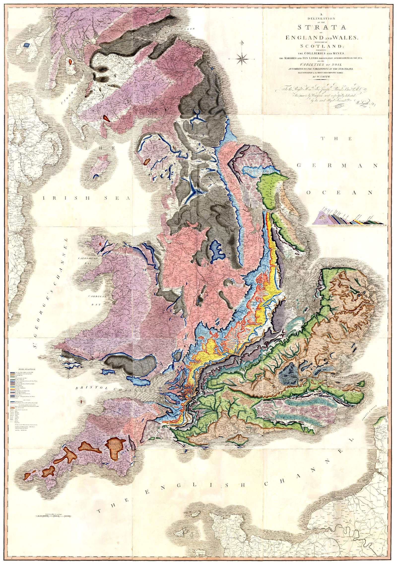
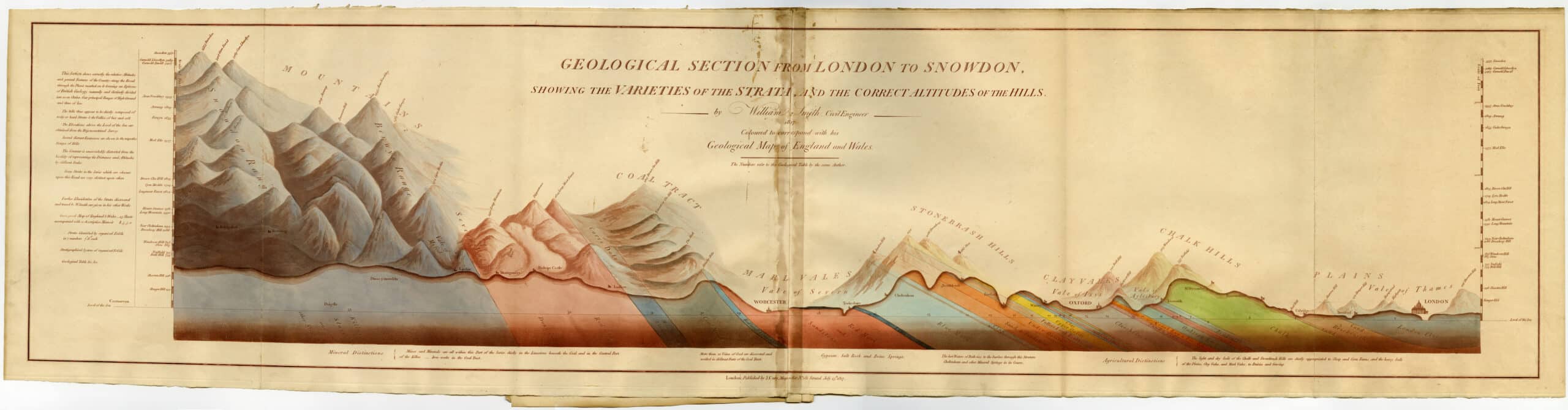
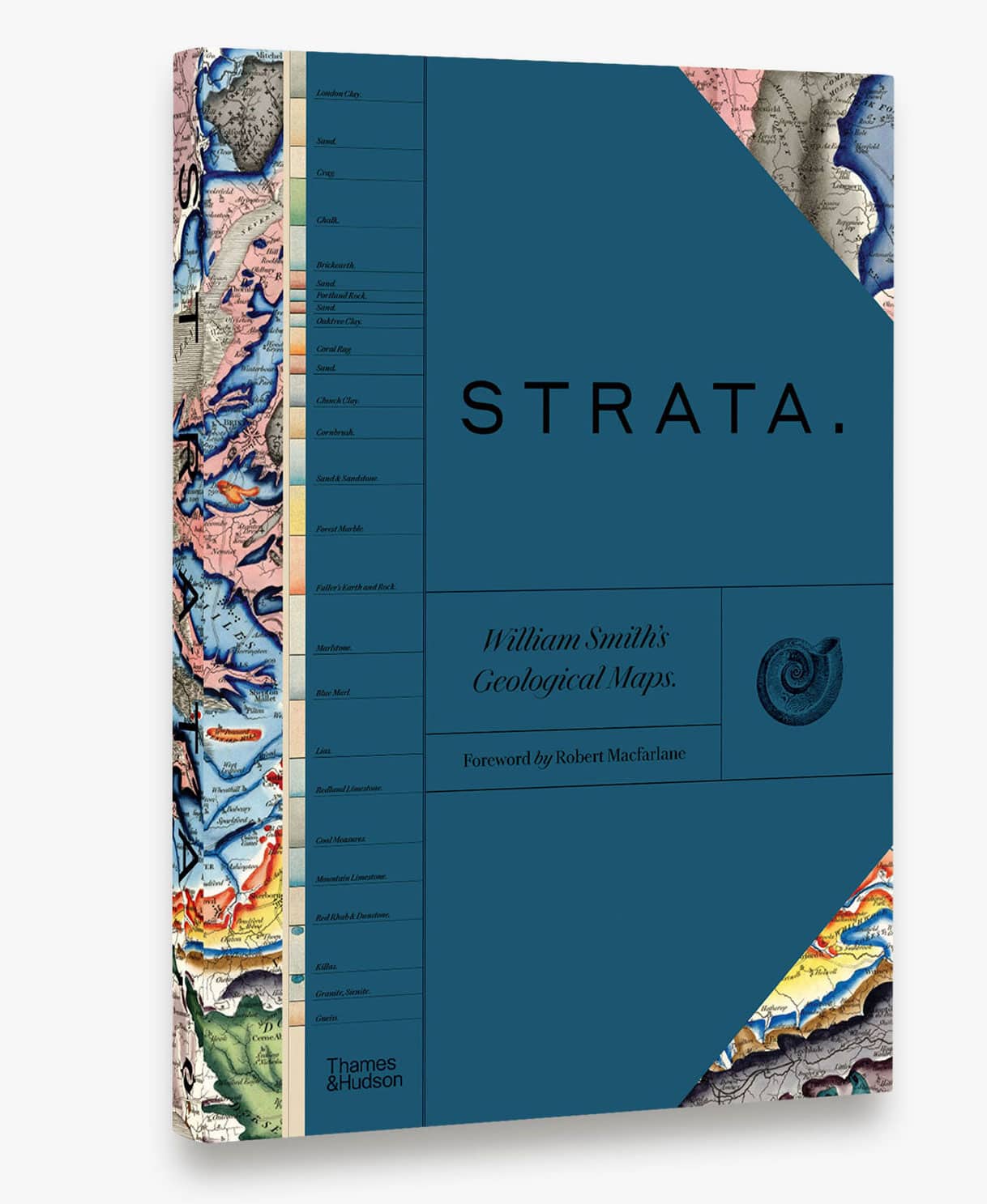
Although he lived and worked several centuries later, there is no better exemplar of the Zilsel Thesis than William Smith, the subject of a beautiful book recently published by Thames and Hudson. Strata: William Smith’s Geological Maps is a comprehensive presentation of Smith’s 1815 map, ‘A Delineation of the Strata of England and Wales with Part of Scotland.’ Smith’s map, based on his extensive field notes, was the first comprehensive geological survey of Great Britain. Through close observation and imaginative projection, Smith was able to describe the island’s underlying geological structure, and to confirm the order and regularity of the strata. The book situates that map, and Smith’s work, in a rich context that includes reproductions of his working sketches and diaries, related maps and drawings, photographs of his fossil collection, and detailed commentary. It is a book that at once takes immense pleasure in the visual quality of the material presented at the same time as it gives the reader the background necessary to understand the extent of Smith’s accomplishment, the historical context of his work, and its implications for the present. It is no small feat to organise such a complex array of information into an intelligible whole, and it has been accomplished with great care and attention to detail. An oversize bookmark, for example, does double duty as a key to the map colours and the strata they represent. As the reader consults the various enlargements and reproductions, this key can be kept at hand as a reference without turning back to the opening pages.
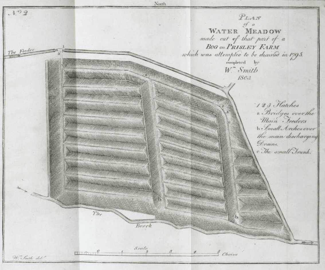
The story of Smith’s life is well told in Simon Winchester’s The Map That Changed the World (2001). The son of a blacksmith, Smith served a five-year apprenticeship as a surveyor, beginning at age 18. Although he had no academic training, he collected rocks and fossils from an early age, and he seems to have had a remarkable capacity to draw broad theoretical conclusions from the raw material he encountered in his day-to-day work as a surveyor and canal engineer. Geology was a vocation for him, an intuitive leap from the practical work he did with the rocks and soil. He also had an uncanny ability to be in the right place at the right time. His work for landowners and coal companies took him all over the countryside, giving him a vast collection of data points that he could begin to shape into an imaginative whole. Along the way, he encountered mapmakers, fossil collectors and amateur geologists, who shared their expertise. He descended into the coal mines to observe and measure the strata, and to consult with the miners about where different fossil species were found. Canal excavations offered readymade cross-sections that revealed local geological features.
But Smith’s life story is also a story of class prejudice, and a corollary distrust of those who make a living from manual work. Although his accomplishments were recognised late in life – at age 62 he received the first Wollaston Medal ‘in consideration of his being a great and original discoverer in English geology’ – his early work was dismissed as unscientific by the Geological Society, and the dating of his fossil collection was questioned. He gave up surveying work to engrave and publish his maps, which left him without a reliable income, leading to a ten-week stay in a debtor’s prison in 1819. By station and by inclination, Smith worked in the field, not in the library or the academy. He stands as a compelling example of the way in which an outsider – an artisan practitioner motivated by intellectual curiosity – can make a breakthrough that overturns the ‘normal’ science and leads to new discoveries. [2] Smith synthesised practical knowledge and closely observed empirical data with abstract speculation and rational science to advance his field.
Digitally archived here.
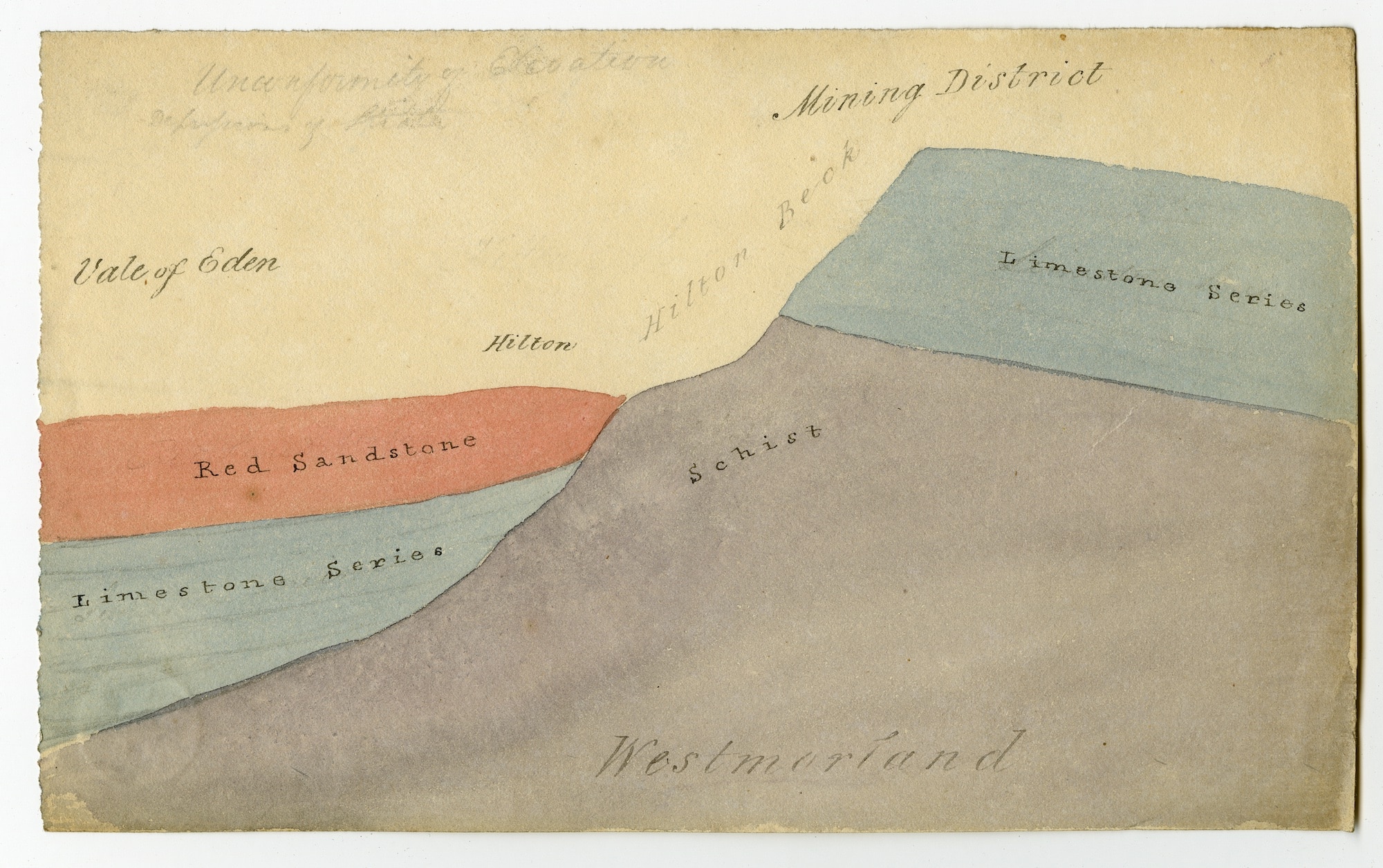
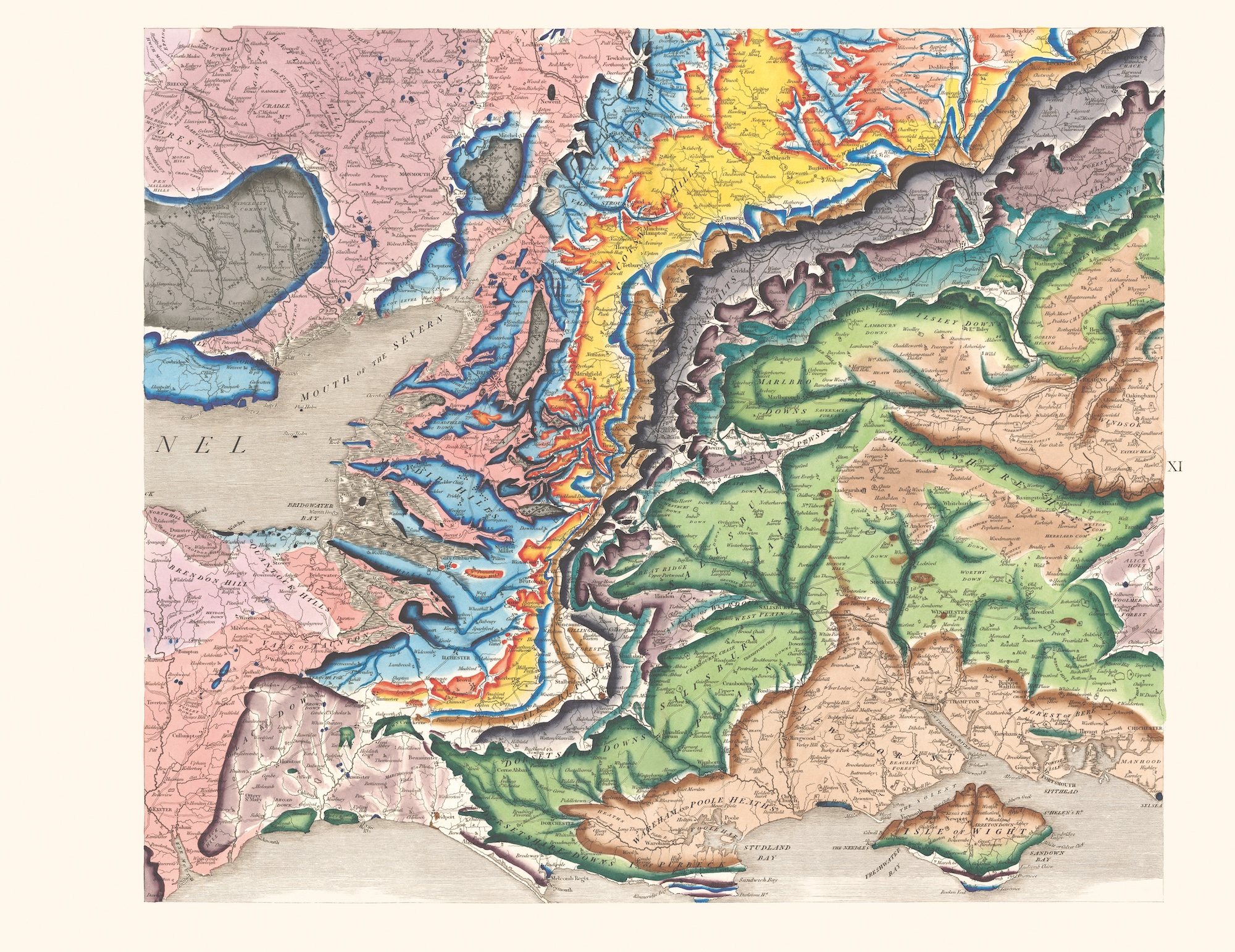
Geology is an art of constructing the whole from the part; as an object of study, it is mostly hidden and can only be sampled in disjointed fragments. It requires an effort of imaginative projection to describe the whole. The structure of the book Strata recapitulates this conceptual framework. The 1815 map was engraved and published in 15 separate sheets. The composite map, and its 15 individual sheets are presented on facing pages at the beginning of the book. What follows is a detailed presentation of associated material, as well as enlarged reproductions of the individual sheets, organised by region. The reproductions are from a copy preserved in the library of the Oxford University Museum of Natural History, and never exhibited; as a result, the colours are surprisingly vivid. The images are woven into the texts, and each page seemingly offers a new discovery: survey drawings, early drafts for maps and diagrams of strata, field notes and sketches, as well as background references, both technical and historical. It is a book that requires some work from the reader, who is asked to perform her own effort of imaginative reconstruction, flipping back and forth from individual plates, details and preparatory sketches to the published and assembled map presented at the beginning of the book. Moreover, as beautiful as they are, the images require decoding: these were also practical instruments, useful to locate coal seams and deposits of building stone or to lay out canals and rail lines.
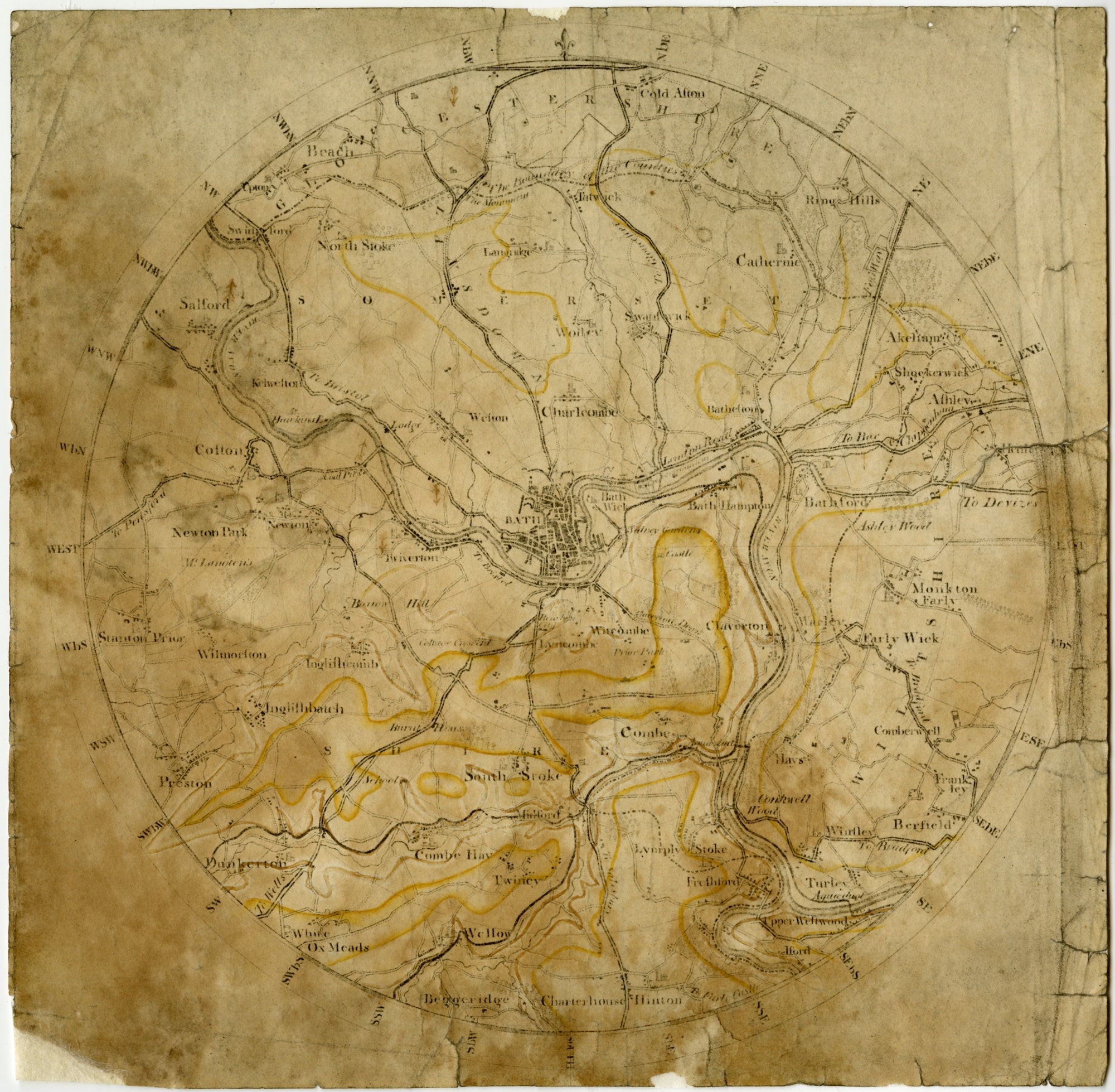
‘William Smith’s early manuscript map of the Bath district from around 1800 shows the outline of the Oolitic Limestone with the colour yellow. The original map scale was 1 1/2 inch to 1 mile.’ (Strata, p. 74).
Geology and architecture share the same geometrical instruments, and architecture at its best is also a synthesis of manual experiment and rational thinking. But beyond the specific operations of mapping that the two disciplines share, there is a larger territory of overlap that speaks to the interaction of large-scale natural systems over an extended time scale. Architecture is always embedded in a specific geological context; but climate change, and the new realities of the Anthropocene make it increasingly difficult to the understand the natural landscape as separate from human intervention. Smith’s life and work, both his close observations and imaginative projections (which included fields, rocks and fossils, as well as roads, settlements, canals, and coal mines), as well as his outsider status as an artisan practitioner, offer valuable lessons for the present.
Strata: William Smith’s Geological Maps (2020) is published by Thames and Hudson in partnership with the Oxford University Museum of Natural History. Find out more about the publication, here.
Stan Allen is principal of SAA/Stan Allen Architect and former Dean of Princeton University School of Architecture.
Notes
- All quotations from: ‘The Social Roots of Science,’ Manuscript of a lecture delivered at Harvard University in 1939, in: D. Raven et al (editors), The Social Origins of Modern Science, (Kluwer Academic Publishers, 2003) pp 3–6. An Austrian Jew, Zilsel was trained in philosophy and mathematics. He was a member of the Vienna Circle around Otto Neurath before Austria’s Anschluss. He emigrated by way of England to the US in 1939, where he received support from the Rockefeller Foundation, taught at Hunter College and later Mills College. He took his own life in 1943. See also: Pamela O. Long, Artisan/Practitioners and the Rise of the New Sciences 1400-1600 (Oregon State University Press, 2011).
- In Charles Lyell’s 1830 Principles of Geology, Smith is credited as follows: ‘Mr. William Smith, an English surveyor, published his “Tabular View of the British Strata” in 1790, wherein he proposed a classification of the secondary formations in the west of England. Although he had not communicated with Werner [Abraham Gottlob Werner, a contemporary German geologist] it appeared by this work that he had arrived at the same views respecting the laws of superposition of stratified rocks; and he was aware that the order of succession of different groups was never inverted; and that they might be identified at very distant points by their peculiar organised fossils.’ Penguin Classics edition, 1996, p. 22.

– William Mann