Wedging a Shrine
This drawing by an unknown author can be appreciated from two different perspectives. On the one hand, it depicts a jinja, a Japanese Shinto shrine. From a historical point of view, the image can be read as an ezu—an illustrated map from the late Edo period (mid-nineteenth century)—featuring premodern calligraphy and the characteristic red hanko seals. The shrine is situated at the top of a hill, accessible via the sandō, an uphill path symbolising purification. As has been observed, ‘most Shinto shrines are located on lonely summits or on remote slopes of the mountains […] The shrines are not places for propaganda or evangelism, but are primarily sacred dwellings for kami (deities of nature).’[1] On the other hand, the drawing can be approached from a perspective closely aligned with architectural representation and graphic technique. These elements, although historical, are more accessible to a Western observer unfamiliar with Japanese traditions.
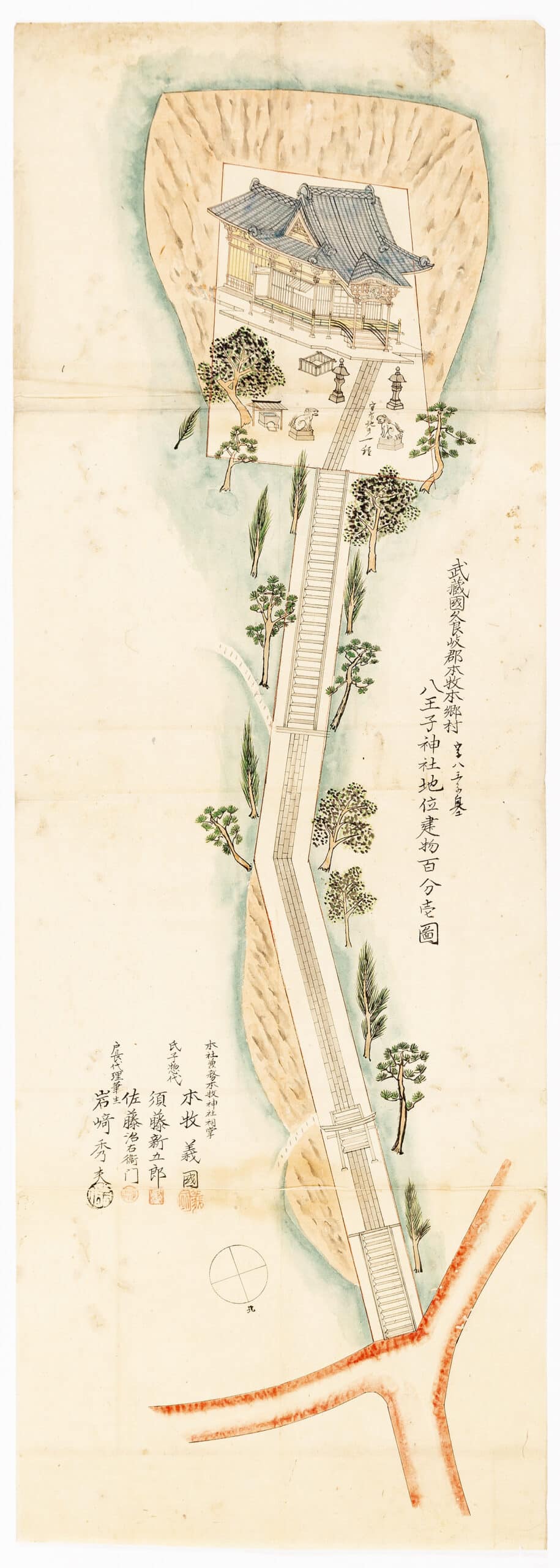
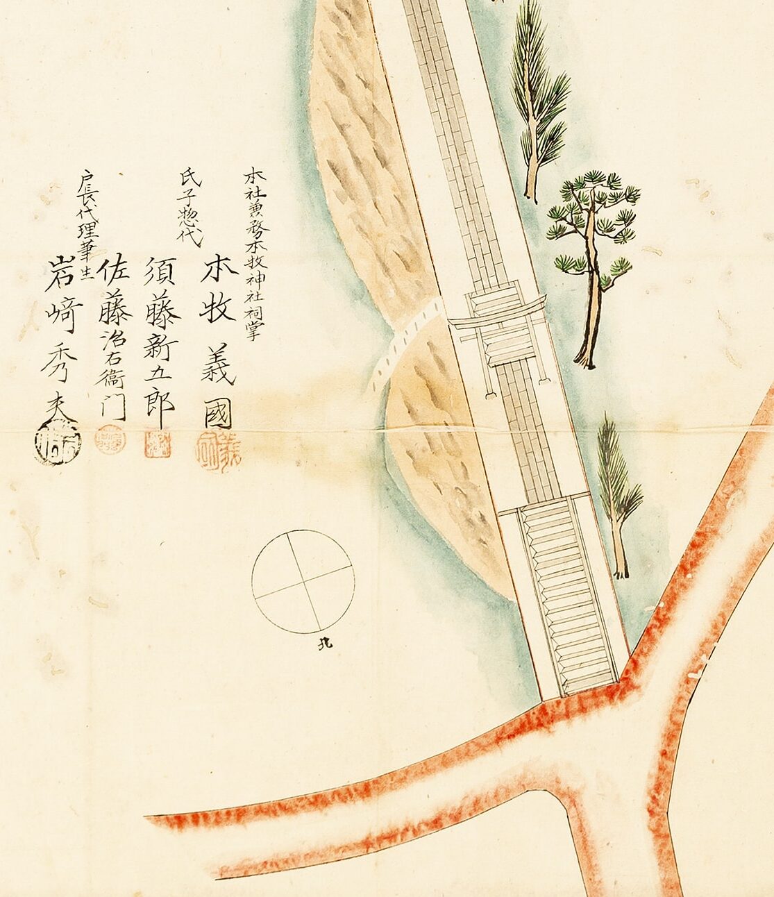
Let us begin with technique: the work appears to employ China ink alongside a water-based medium for the application of colour. The ink was likely applied using fine-tipped nibs or small brushes, depending on the subject depicted. The shrine itself is rendered with a striking level of detail, a quality made possible by the large format of the drawing. Broader brushes, by contrast, seem to have been used to fill in the shaded greens surrounding the hilltop where the shrine stands, the rocky textures, and selected areas of the roof, vegetation, and paving. Over time, the ink has undergone slight discolouration, turning reddish in certain areas. The colours have also lost some of the original saturation. The streets at the bottom are deliberately rendered in red, marking them as access routes rather than sacred spaces and thus distinguishing them through a different chromatic approach. The paper itself shows folds and signs of deterioration, lending the drawing an appearance that may seem older than it actually is.
The methods of representation become particularly intriguing. The map likely dates back to the late Edo period (1603–1868), as suggested by its style and the meticulous graphic attention to detail, including the indication of north and the careful rendering of the building. As in many Japanese representations, attempting to reduce the image to a Western geometric system may be futile. Instead, the drawing is better understood as a layered composition. Oblique drawing was a canonical method of representation in Japan following the adaptation of Chinese artistic conventions from the seventh century onward.[2] At the same time, many works of the period do not adhere to strict geometric rules, but are instead guided by key concepts associated with the ezu, a hybrid form between map and painting. In an ezu, spatial and geographical elements coexist with symbolic, narrative, or functional ones. These are not intended to convey realistic proportions or accurate measurements but rather to communicate spatial relationships, hierarchies, land use, and religious significance. They are pictorial diagrams without a fixed scale, in which important landmarks are often exaggerated.[3] From this perspective, a purely geometric analysis becomes beside the point. The drawing combines planar and axonometric modes to achieve clarity and emphasis.
In this case, what matters is that nothing important is hidden: details and routes useful for orientation are clearly shown. An entrance staircase, the torii, a paved path, another staircase, and finally the sacred space of the shrine. There is no single viewpoint governed by fixed axonometric axes, but rather a multiplicity of perspectives: the slope flattens toward the left, while the trees are oriented in different directions, visually opening along the path. The forest becomes a green halo, as the trees punctuate the journey and mark its rhythm.
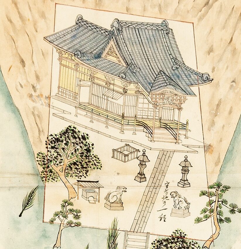
At last, we reach the shrine: a distinct scene governed by a different set of rules that override those seen so far. The komainu, always arranged in pairs, seem to establish a perspectival order, as do the lanterns positioned after them. Together, these four elements flank the paving, which is rendered in plan view, lying on the surface of the hilltop. The fountain and the enclosure introduce additional directional cues, yet it is the shrine that displays the most significant level of detail. It is represented using a form of axonometry that can retrospectively be identified as cavalier (or cabinet projection): the frontal elevations maintain their true proportions on the X and Y axes, while depth is suggested through a tilted—and possibly shortened—Z axis. Richly articulated, the shrine is unmistakably the protagonist, the destination of an observer who, experientially, starts at the entrance below and ascends the hill. Each element reads as a stage in a gradual process of purification.
One final detail—small yet revealing—concerns how the platform on which the temple stands is drawn. It extends beyond the limits of the hilltop, so instead of resting on its area, the temple appears wedged beneath it, as if the draughtsman had adjusted for an excess by adding colour and shading to conceal an already completed construction. As a result, the shrine, in its three-dimensional form, seems to project outward from the two-dimensional area while simultaneously being constrained by its edges, which we perceive in a kind of transparent overlay—reminiscent of the protective corners used for fragile sheets in museums. It almost appears as if the shrine is an object belonging to an additional representational plane, superimposed atop the many others already present.
This choice can be linked to the act of enclosing the space, a characteristic of Japanese spatial culture. ‘Enclosure is the result of surrounding an object or a space so as to “inform” the contained space or object. An enclosure can be thought of as a wrapping and is quite a distinctive aspect of Japanese space.’[4] The shrine, in this case, is firmly enclosed within the area at the top of the mountain, as if the author wished to ‘wrap’ it, making clear that the sacred building belongs to that defined space and does not extend beyond it.
The result is an unintended optical effect in a work by an anonymous artist whose primary aim was likely to anchor the shrine securely within its sacred domain. Today, this choice allows us—even as non-specialists—to appreciate the complexity of Japanese spatial thought and the intriguing, sometimes unexpected, methods by which it is represented.
Notes
- C-Y Chang, Japanese Spatial Conception 3. The Japan Architect (June 1984), 63.
- Kenneth G. Henshall, Storia del Giappone (Milano: Mondadori, 2018), 3.
As Massimo Scolari defines it in the homonymous book, Oblique Drawing: A History of Anti-Perspective, trans. by Jennie Condie Palandri (Cambridge, MA: MIT Press, 2015).
- G. L. Ledyard, ‘Cartography in Japan’, in The History of Cartography, Volume 2, Book 2: Cartography in the Traditional East and Southeast Asian Societies, ed. by J.B. Harley and David Woodward (Chicago: University of Chicago Press, 1994), 349.
- C-Y Chang, Japanese Spatial Conception 7. The Japan Architect (October 2024), 61.
*
Federico Rebecchini is a postdoctoral researcher in the Department of History, Drawing and Restoration of Architecture at Sapienza University of Rome. His work focuses on analogue drawing, the relationship between architecture and comics, and experimental forms of publishing.
This text is one of the selected responses to the first category of the Open Call 2025: Visibility, and the Unseen—a series of short contributions that either bring to the surface the unseen drawings within the Drawing Matter Collection (I. In the Archive) or explore original architectural drawings, created by the author(s) of the contribution, which make visible the unseen (II. In Practice).
