Polyconal System Projected into the Unknown
That thing the nature of which is totally unknown to you is usually what you need to find, and finding it is a matter of getting lost.[1]
I feel like I am about to start writing an unauthorised account of this building, or system, that is presented in front of me. Of course, I have fully manufactured this specific situation, where washed-out pinks and greys allow for a specific imagining of a time past; a specific mode of making sense of the unresolved; a specific tone and timbre and care that I may need to weave into the words that follow.
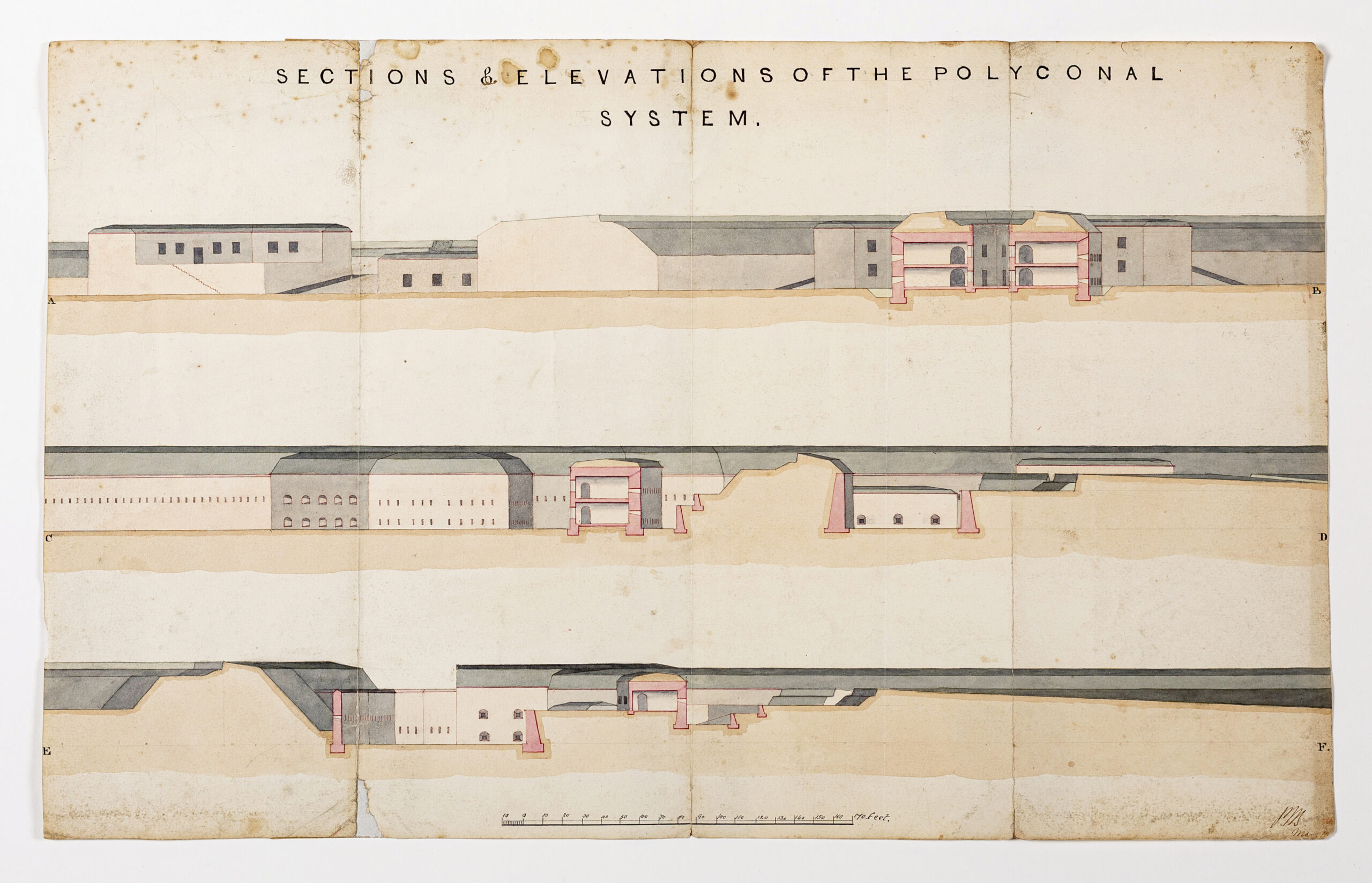
The building, labelled as Sections and Elevations of the Polyconal System, embeds itself into the landscape in a series of blush pinks holding up and on: in the soil around it, as thick retaining walls; or the structure itself, lending stability in deep, stretching, longitudinal forms. A quick Google search yields no information on the origin of the word polyconal, but the extensive search that followed fetched some conjectural fragments that I will detail in this largely imagined retelling of stories.
What kind of places do these unrecorded, imprecise retellings—the archival record, documented inexactly, described with unknowns—bring into existence?[2]
To transversally cut into this first conjectural narration, my first sense of ‘polyconal’ is a reference to a projection system, specifically the American Polyconic Projection system, known to cartographers—and possibly not many others—as a device for minimising distance distortion at large scales.[3] Interestingly, cartographer Mark Monmonier states that the longevity of this certain mode of projection, used across the United States from the early 1880s until the 1950s, represents a ‘bureaucratic inertia[,] as well as any map projection’s potential significance as a graphic signature’.[4]
This particular version of a narrative conjures up echoes of imperialist impetus à la manifest destiny, where cartography perhaps had worked in the favour of expansion under the guise of exploration. Yet, I feel unsettled with this preliminary conclusion. I look back at the few descriptors on the drawing’s catalogue record to make sense of my unease. The ‘principal name’—author or maker—returns ‘Unknown British School’, and it is ‘[i]nitialled and dated (illegibly); scale in feet’. The medium: ‘Pen, ink and wash on Whatman 1855 paper’.
We can glean a couple of things from these fragments. Whatman paper in 1855 was the finest paper available at the time.[5] It led to prosperity for the Whatman family who manufactured it, and made for many masterpieces of Romantic watercolour. The story goes that both state and world leaders favoured it: George Washington used it for his state papers, Queen Victoria for her personal correspondence.[6] However, I feel this particular strand of thought can be put to rest for now. I dutifully reference writer Rebecca Solnit’s A Field Guide to Getting Lost, where she posits:
Search-and-rescue teams have made an art of finding and a science of how people get lost…[7]
Let us return to landscapes of ink wash—the drawing of the polyconal system. A quick glance with a ruler on my printed (monochrome) version of the drawing indicates that the long volumes of the building are approximately 10 metres in width, and the retaining walls of the courtyards nestle within a hill of just over 10 metres in height. It seems that the mound of soil dividing the two outdoor spaces of the building may be artificial in nature. The topmost section shows the strongest traces of a narrative of cones, in one seemingly circular structure wrapping around another smaller circular structure, with windows peering into an internal atrium, also 10 metres in height.
We approach the ending of this account with another healthy dose of imagination towards the actual or proposed form of the polyconal building. The limitations of this mode of architectural drawing are characteristically orthogonal—the determinant of curved, conical form only visible in washed-out variants of grey. To make sense of this evocative landscape, through the infill of previously acquired knowledge—and to repeat a question previously posed towards this method of writing: what kinds of places do they bring into existence? What kinds of places do assemblages and fragments of collected, combined, knowledge garnered from the imaginary—collective or otherwise—bring into existence?
I reflect on the nature of the various modes and manners of representation that come embedded within this drawing, a fragment unearthed from a digital archive. The nature of an orthographic section intentionally exchanges perspectival depth for a stronger legibility in its formal relationships; it also highlights what is built alongside the equally intentional landscape that surrounds it. And beyond the drawing itself—its digitised vessel: the digital archive offers a small, concentrated glimpse into the wider physical collection it dwells in, amplifying the inherent nature of an archive to imply, reflect, and speak to what is lost, chosen, and seen. To make more visible the unknown is to move between ‘the scholarly and the fictional’[8]; to acknowledge that the act of being lost is filled with potentialities that reframe the relationship between absence and what is already known.
Notes
- Rebecca Solnit, A Field Guide to Getting Lost (Penguin Publishing Group, 2006), 6.
- Catharina Gabrielsson et al., ‘Reading(s) and Writing(s): Unfolding Processes of Transversal Writing,’ Writingplace 3 (December 2019): 4.
- Mark Monmonier, ‘Practical and Emblematic Roles of the American Polyconic Projection,’ Wiener Schriften Zur Geographie Und Kartographie (Wien, 2004), 93.
- Ibid.
- Alison C. Kay, ‘Whatman Paper – Victorian Professions Blog,’ Victorian Professions Blog, May 5, 2016, https://victorianprofessions.wordpress.com/tag/whatman-paper/.
- Turkey Mill, ‘Turkey Mill – History,’ Turkey Mill, October 6, 2025, https://www.turkeymill.com/about-us/view/139/history/.
- Solnit, A Field Guide, 10.
- Gabrielsson et al., ‘Reading(s) and Writing(s)’, 4.
*
Qing Tang is an interdisciplinary architectural historian, artist, and writer. Her research and artistic practices reflect on digital histories, experimental cartography, and commoning in architectural communities.
This text is one of the selected responses to the first category of the Open Call 2025: Visibility, and the Unseen—a series of short contributions that either bring to the surface the unseen drawings within the Drawing Matter Collection (I. In the Archive) or explore original architectural drawings, created by the author(s) of the contribution, which make visible the unseen (II. In Practice).

– Michael Chapman