Guy Debord

‘But I must here, once and for all, inform you that all this will be more exactly delineated and explained in a map, now in the hands of the engraver … not to swell the work … but by way of commentary, scholium, illustration, and key to such passages, incidents, or innuendoes as shall be thought to be either of private interpretation, or of dark and doubtful meaning after my life and my opinions shall have been read over (no don’t forget the meaning of the word) by all the world …’
Guy Debord quoting Sterne, The Life and Opinions of Tristram Shandy [1]
For Guy Debord the problem and critique of modernist urbanism in itself drew on cartographic and photographic techniques, and even the ‘evidence’ put forward by planners themselves. On the one hand, this was the result of the entirely self-conscious strategy of détournement, of using the enemy’s material against itself; but on the other hand, it also represented a kind of collusion based on a mix of nostalgia for the original aims of a modern urbanism – for what avant-garde urbanist did not dream of a unitary solution? – and a historical sense that alternative traditions, rooted in the seventeenth century conflict between Cartesians and Pascalians, had been suppressed. For Guy Debord, in particular, the maps, ideal and real, that traced the settlement of the earth, and the aerial photographs that viewed these settlements in all their three-dimensional complexity, were charged with more than their official origin. From the outset they acted as objects of memory, reflection, and strategic plans.
The dérive is a product, not of concentration, but of ‘distraction,’ a ‘technique of displacement without any aim’. [2] Meynier describes the principles of mapping a territory, from the very local to the global, with detailed comparisons between aerial photography – images taken at oblique angles – and geometrical plans. Where the photograph ‘taken at low height allows one to see all the details: number of houses, trees, railroads, roofs and limits of properties,’ the map, at the same scale allows scale to be measured, but shows only a few details. [3] In this comparative method we can begin to see the germ of Debord’s cartographic imagination – one that moves from aerial photographs to ideal maps, to his own constructions, with all the rigour of a precise détournement, one that preserves the fundamental roles of photographs and maps as guides, but now to a ‘way’ that has not been mapped before.
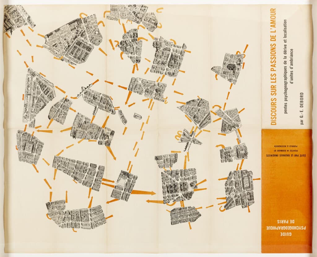
More directly, the effect of the Carte is manifested in the collage map of Paris constructed by Debord in 1956 under the title ‘Guide psychogéographique de Paris,’ and published in Denmark by Jorn in the series of the new ‘Bauhaus Imaginiste.’ Vincent Kaufmann has termed it ‘another carte de Tendre (or more precisely the first one),’ and pointed to the sub-title of the map: ‘Discourse on the Passions of Love.’ [4] This, of course, joins the map as a symbolic return to the celebrated essay, attributed to Pascal, and probably written between 1753 and 1754, also entitled Discours sur les passions de l’amour. [5] The distinction drawn by Pascal between geometrical and subtle minds, and those driven by ambition or by love, as well as his conclusion that youth should be driven by both love and finesse was evidently appealing to Debord, as was the idea of constructing his own version of the Carte de Tendre, delineating not the rivers towards Tenderness, but the ‘psychogeographic slopes’ traced by the urban dériveurs as they sought to define hitherto unknown territories according to the sense of their ambient unity.
Even more intriguing was the choice of the map of Paris, the pieces of which formed the collage. The ‘Guide Psychogéographique’ selected a bird’s-eye view meticulously drawn by G. Peltier and published by Blondel la Rougery in 1951. Consciously modelled on the celebrated Turgot map of Paris (1739), it showed the city in perspective, at an angle roughly equal to the point of view established for the Carte de Tendre. This oblique view, as opposed to the geometrical survey of the map, offered a sense of place, space, and buildings analogous to the aerial photograph, allowing for the viewer an imaginary entry into the urban fabric. Indeed, in the same year Debord will go so far as to credit Chombart with the perception that an urban neighbourhood is defined by more than the sum of its geographical and economic factors, but also ‘by the image that its inhabitants and those of other neighbourhoods have of it.’ Data of this kind, noted Debord, were ‘examples of a modern poetry capable of provoking sharp emotional reactions.’ [6]
Notes
1. Guy Debord, Panegyric Volumes I and 2, trans. James Brook and John McHale (London: Verso, 2004), p. 167.
2. G.-E. Debord, Jacques Fillon, ‘Résumé 1954,’ Potlatch 14 (30 November, 1954), p. 53.
3. Géographie, p. 22.
4. Vincent Kaufmann, Guy Debord: La révolution au service de la poésie (Paris: Fayard, 2001), p. 160.
5. Pascal, Blaise (attrib.), Discours sur les passions de l’amour (1652–1653) ed. S. Pestel for the electronic collection of the Bibliothèque Municipale de Lisieux (27.X.1999), on the basis of the edition edited by Jacques Haumont (Paris, 1940) : http://www.bmlisieux.com/
6. Guy Debord, ‘Theory of the Dérive,’ in Liero Andreotti and Xavier Costa, eds., Theory of the Dérive and Other Situationist Writings on the City (Barcelona: Museum of Contemporary Art of Barcelona, 1996), p. 22. The original article, ‘Théorie de la dérive,’ was published in Les Lèvres Nues no. 8, 1956, and was reprinted in Internationale Situationiste no. 2 (December 1958), pp. 19–23.

– Sheila O'Donnell