The Silent Lines of the Paper Landscape
Survey Drawings of a Rural Irish Village
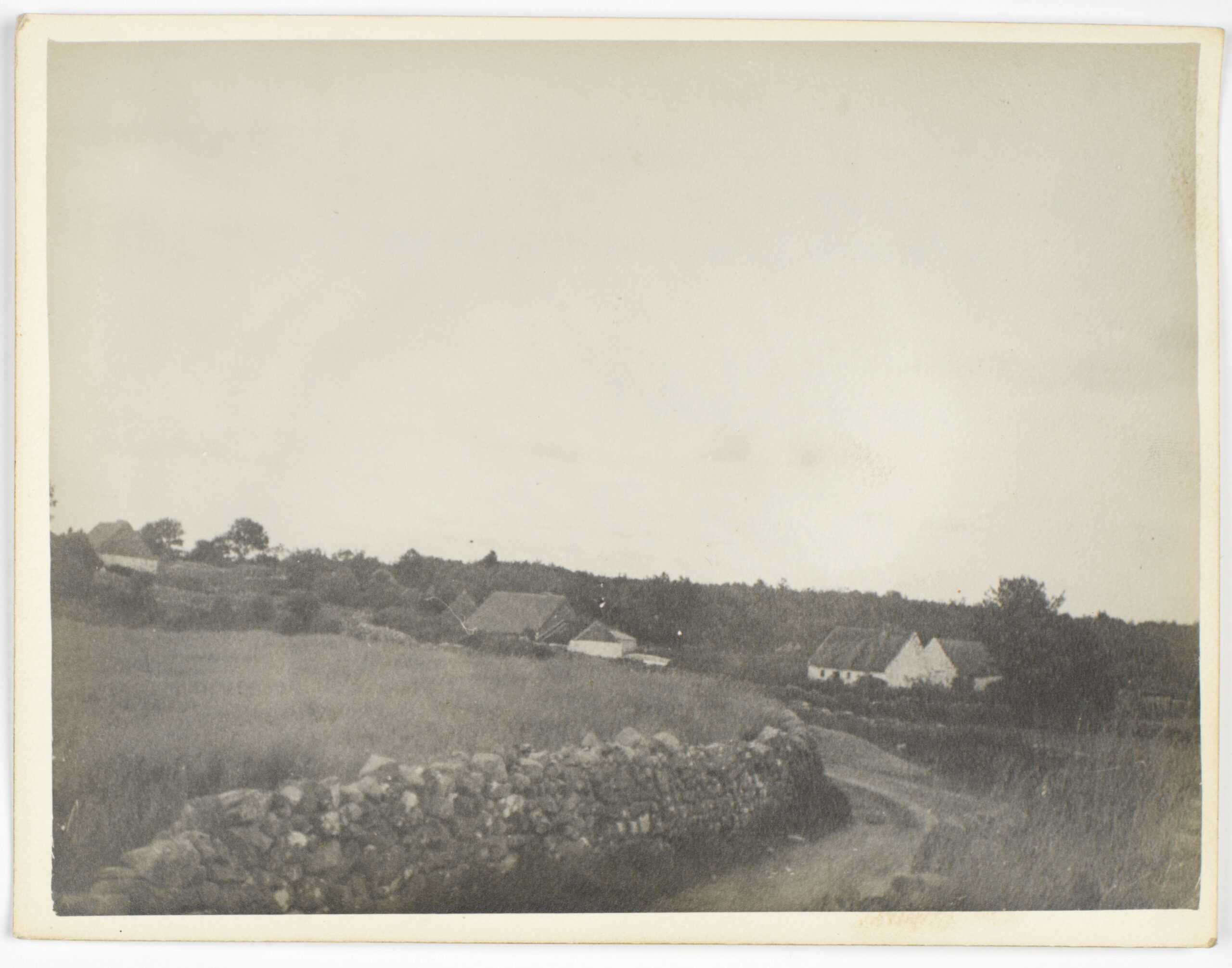
This essay discusses the role of the survey drawing in the representational portrayal of a particular place, the historic community of Menlo in the west of Ireland: a village that emerged as a residual ‘clachan’ settlement, following the establishment of a castle in the sixteenth century.[1] Three different survey drawings and maps are examined, each produced at a pivotal moment in the context of the wider national societal landscape.
*
1839. The Map as Artefact.
In 1824, the British state commissioned the first comprehensive large-scale topographical survey of Ireland. Officially seeking to address inequalities in local taxation, these documents would also greatly assist in conquering ‘the opacity of the Irish landscape’.[2] They were produced at a key moment in the history of the island, directly prior to the outbreak of famine, in which almost four million people—half of the entire population—either died or emigrated.[3] The landscape was irrevocably altered.
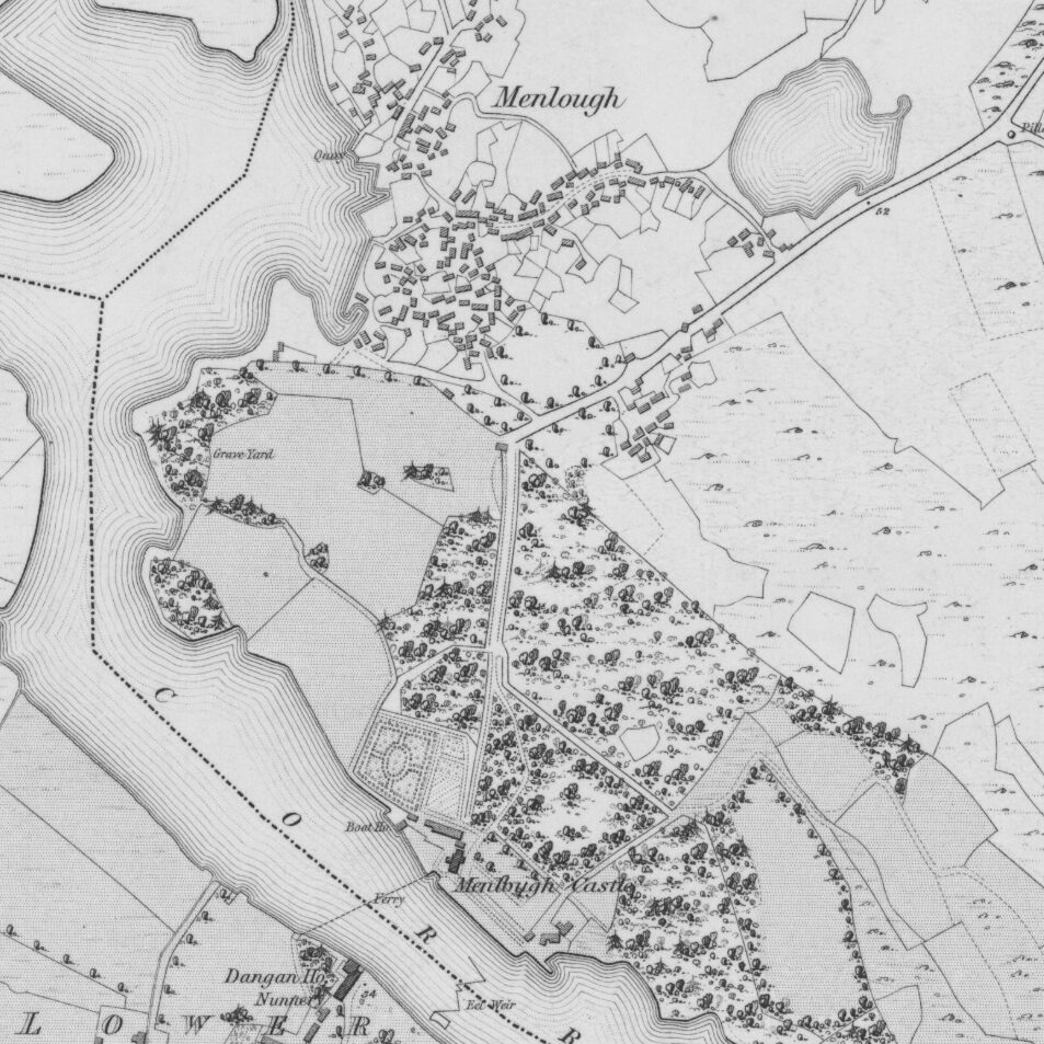
Systems of classification and modes of representation are often established by those in power and serve to reinforce ‘the role of the map as a form of social proclamation’.[4] In the survey map of Menlo (Fig.2), the castle near the bottom is shaded in dark grey, a much more pronounced tone than the buildings in the surrounding context. It is highlighted to those viewing the map: it is isolated, metaphorically projecting from the physical sheet or digital screen, and its importance is implied through this graphical hierarchy. According to geographer John Brian Harley, ‘the concept of a tiered territorial society was not lost on contemporary map makers’, who, as employees of the state, evidently favoured the status quo.[5] The land within the boundary of the estate is hatched with a densely spaced dot pattern. The blank fields around the village, however, are not assigned any designation, adopting the colour of the printed base medium. The ambiguity of these fields sits alongside the clear definition of the castle grounds, further strengthening the disparity in relations between poor local tenant farmers and the wealthy landlord class.[6]
Though the commissioning of independent mapping projects was forbidden once the Ordnance Survey had begun, many landlords had previously used private surveys to formalise the layout and design of their estates in print.[7] These cartographies became symbols of the control and ownership of land and were often directly referenced or even copied by the Ordnance Surveyors as signs of verifiable truth. The illustration of the landscaped gardens and individual trees surrounding the castle (Fig.2) is a reproduction of the influence of the landlord authority over the field surveyors. The landowners directly influence the representation of these maps: control not only over the physical landscape but also the process of documentation that creates its visual depiction. Within the rural grain of the village core, the primary route appears to disintegrate as it meanders from the periphery to the centre. The dwellings and outhouses, represented by consistently sized rectangular blocks, lose their relationship to the street and appear to float amongst themselves, as if they had fallen ‘in a shower from the sky’.[8]
Described as ‘silences’ by Harley, these omissions make expressly visible the biased decisions, both conscious and unconscious, made by the surveyors and mapmakers in the production of the document.[9] Conversely, the principal thoroughfare leading to the castle grounds is highlighted in a thick, solid black line.
*
1945. A Village Already Made.
In collaboration with the Irish Folklore Commission and the National Museum, a group of architecture students from Dublin were dispatched to the west coast, seeking to survey and record traditional dwellings in the vernacular rural landscape.[10] They arrived in Menlo in the summer of 1945, after their regular ‘grand tour’ excursions to Europe were curtailed by the outbreak of war.[11] Though changed considerably since the Ordnance Survey project, the students found a place that remained largely isolated from urban life.
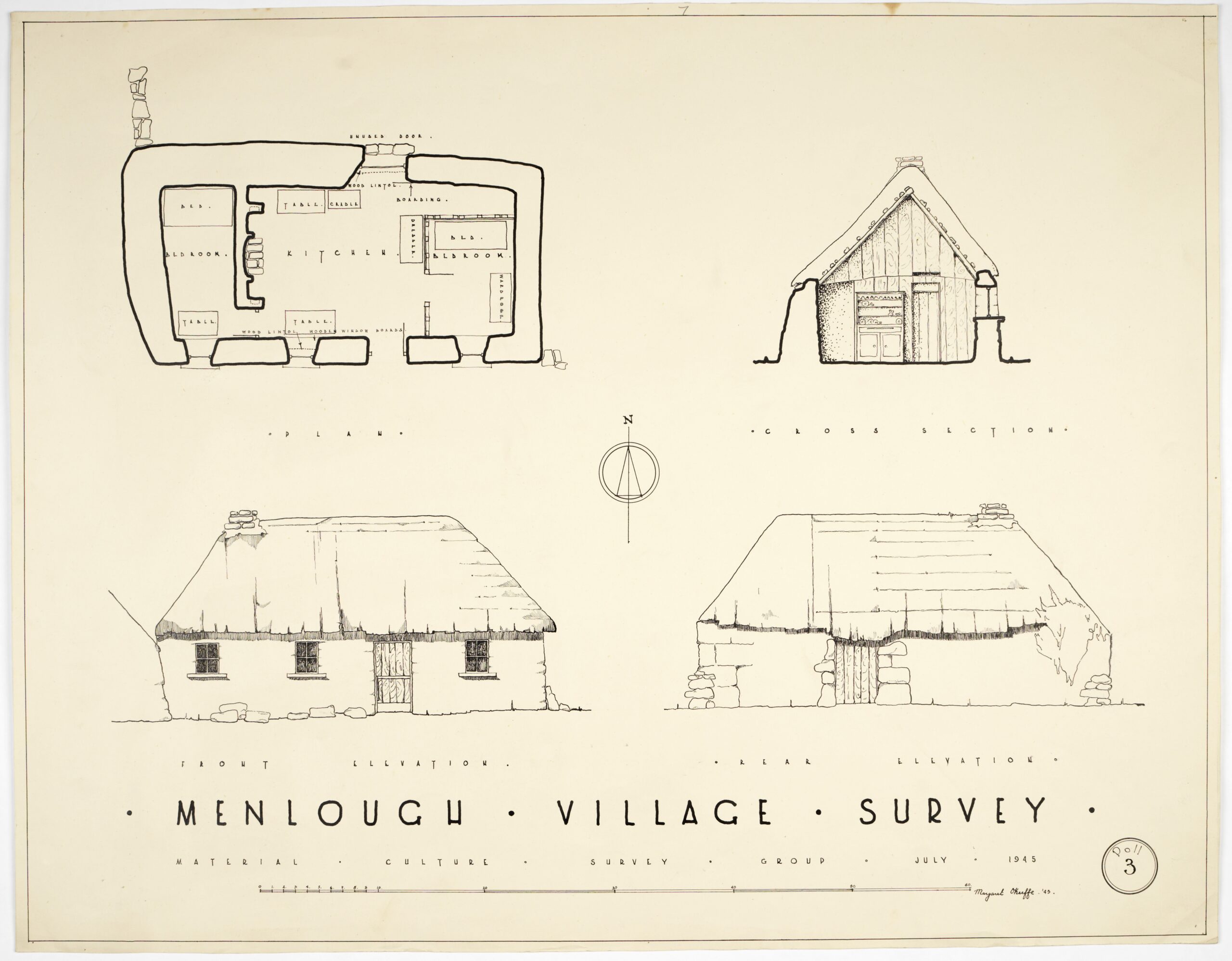
In one drawing, a cross-section (Fig.3) illustrates the irregular relationship between the walls and roof of a dwelling, where the ridge is shown off-centre relative to the walls below. It results in a decidedly lop-sided arrangement and a sense that the structural integrity of the house is under threat. The asymmetrical roof is not immediately noticeable by outside observers, highlighting how the idiosyncrasies of a building are often hidden within its fabric; the history of a place is only revealed through the lived experience and bequeathed stories of its occupants. In this case, the owner noted to one of the students that the roof had slipped during remedial works to the collapsing walls.[12] The unique qualities of a particular dwelling are often omitted from survey drawings to allow for the emergence of a simplified ‘type’ form, transformed into a series of ‘abstracted drawings showing only the predominant similarities’.[13] As noted by Andrew Clancy, the reduction of the specific to the generic, though enabling the uncovering of changes previously unseen, risks precluding from consideration elements that define the individual house.[14] The direct engagement of the surveyor with the occupants of the dwelling, and the building itself, led here to the revealing of a part of the building’s history.
Further, significant deviations in the depth of the external walls are evident in both plan and section, conveyed through the loose qualities of the hand drawing. The accompanying report notes that ‘part of this cottage is believed to be the oldest building’ in the village; past issues with the structure resulted in significant interventions by the owner.[15] The survey drawings—intended to document the building at a specific moment in time—reveal the temporal layers embedded in the material fabric of the house: ‘these buildings evolve in an unselfconscious manner, arising from the daily patterns of living developed over a lengthy period of time, and linked to available skills and materials’.[16]
Although the clachan is historically associated with disorder and chaos,[17] the selection of a site for a house ‘was a matter for the most careful deliberation’, according to geographer and archaeologist Estyn Evans.[18] In one dwelling, a ninety-four-year-old man expressed to the students his disapproval of the building works undertaken by his father, insisting that the width of the kitchen should not exceed 13 feet and six inches. In reality, the room was 15 feet wide. The surveyors noted the possibility that these dimensions relate to the structural span of the timber roof members.[19] Such specific and exacting knowledge regarding the physical material fabric of one’s home suggests that the dwellings and the people within them share lives that are intimately entangled, one inextricably linked to the other. A command of the specificities of traditional construction aligns with the view that there is ‘a well of knowledge embedded in these structures, one that exists beyond their direct qualities as buildings per se, and rather as structures which enable us to understand a society’.[20] The survey is thus elevated from a perceived literal transcription of the physical landscape to one which embodies the rituals, culture, and living memory of a place.
However, the influence of the original Ordnance Survey still loomed over the enterprise. With little choice but to utilise these maps as a base, the students adopted the now established nomenclature of the colonial state through the duplication of place names that first appeared on these cartographic artefacts. The release of the surveys formalised these names, thereby exacting ‘a measure of multivalent subjugation’ upon the native language.[21] The name of the village, ‘Menlough’, is an anglicised version of the Irish word ‘Mionloch’, meaning ‘small lake’. Deep connections between place, language, and topography are severed by the colonial project, and these already-anglicised words are modified further in more meaningless ways. Today, the village is known simply as ‘Menlo’.
*
2012. The Incomplete Survey.
In the years following the economic crisis of 2008, a group of architecture students from ETH Zurich arrived in Galway. They sought to document various parts of the city, with a view to forming their own design proposals in response. Led by architect and educator Tom Emerson, the project brief deliberately acknowledges the biases of the surveyors in the drawing process, and the survey becomes the first step in the method of design. One of these drawings shows a traditional dwelling (Fig.6), located in Menlo, also drawn by the students from Dublin over 60 years earlier (Fig.3).
The drawing frames an orthogonal view from above of a thatched cottage and outhouse building, one perpendicular to the other. The projecting dry-stone walls disappear off the sides of the page, unconstrained by the combination of metric drawing scales and standardised paper sizes. These limitations are imposed by the tutors as a deliberate part of the drawing process.[22] The reductive qualities of the drawings—light black lines, no solid infill or hatching—highlight the differences in execution and content between the individual students, or surveyors. The unfinished drawing is indicative of how the dwelling is part of a wider whole. Perhaps the surrounding walls converge just beyond the cropped sheet? Or is there an opening in the stonework? Emerson notes that the survey, as much as the design proposal, ‘is borne of the imagination’.[23] It is true that much of the drawing is left to be interpreted by the viewer. Indeed, if the image had been extended to the right by just a few metres, a stone pillar ‘cross’ would be revealed. Its significance to the local population relates to the suggestion that it once marked the site of an important marketplace.[24]
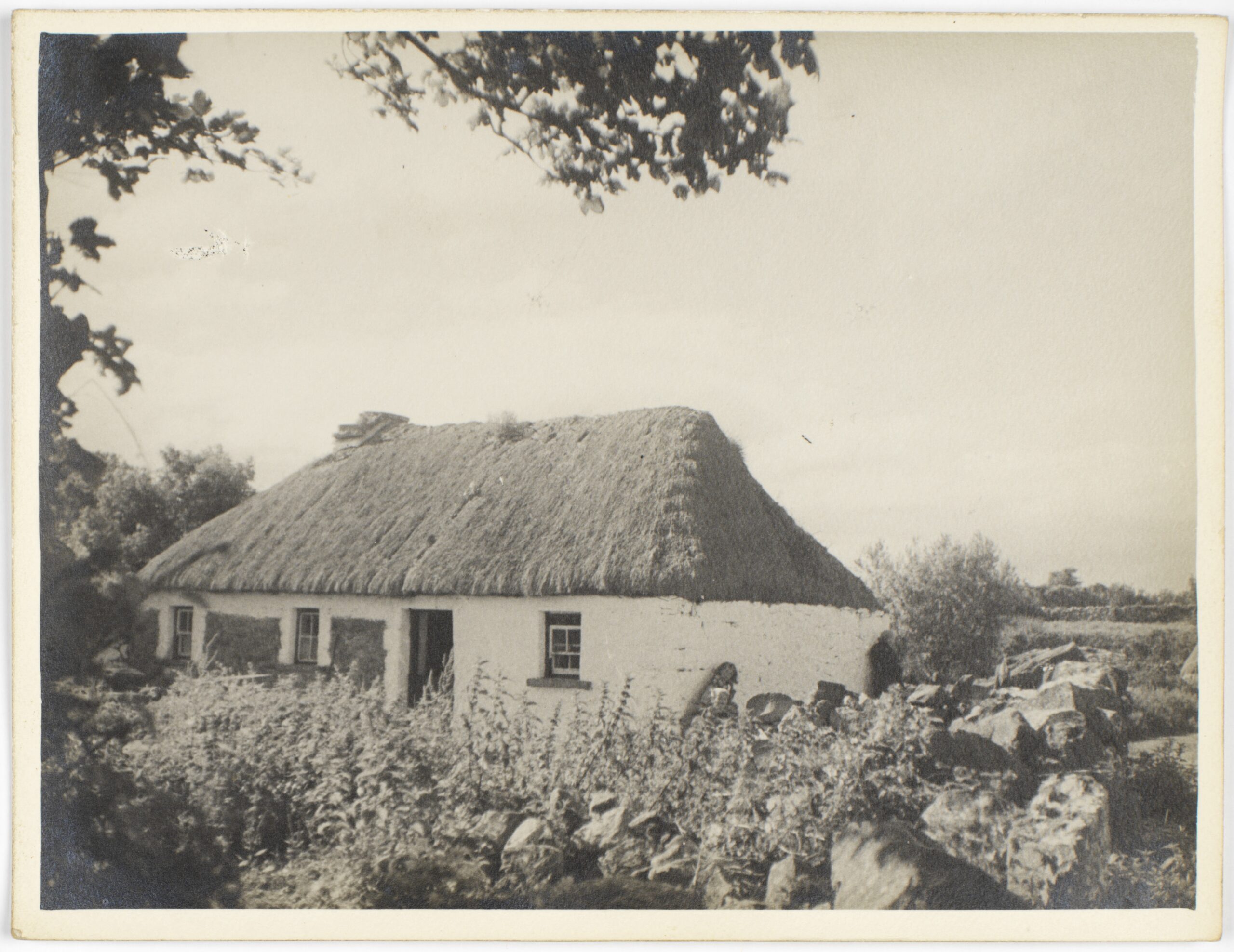
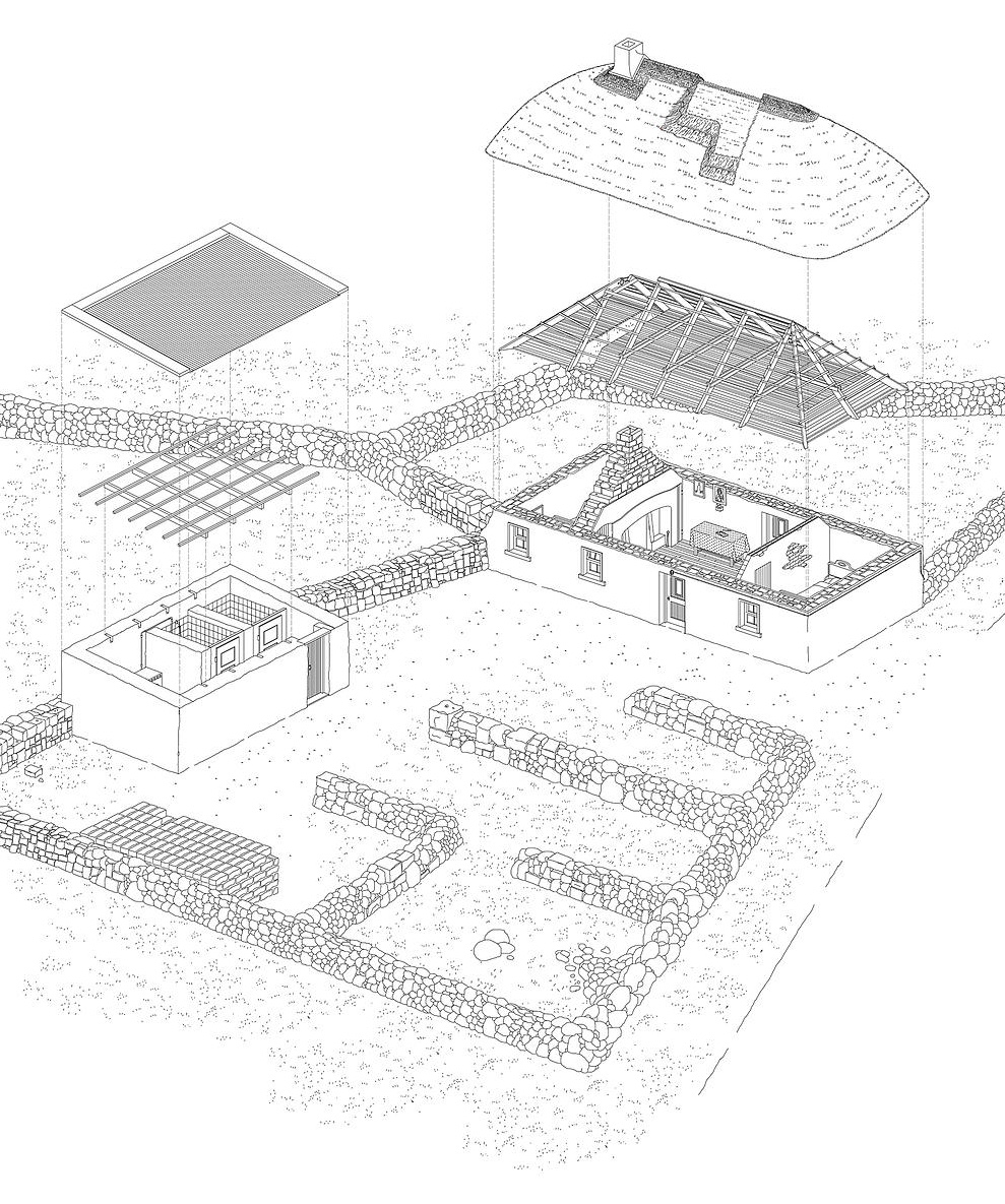
The drawing, like the dwelling, is a fragment; here it was never intended to be presented as a singular, autonomous element. Each drawing was published as part of an ‘atlas’ alongside a photograph of the same size, a snapshot of authenticity that testifies to ‘a kind of realism, a proof that these spaces exist’.[25] The isolation of the drawing from the atlas mimics the removal of the dwelling from its immediate context as part of a connected settlement. It suggests that the importance of these structures lies in the cultural significance of the communal evolution of the place. Just as the architectural drawing is ‘part of a collaborative process which does not easily conform to the idea of the individual artist-author’, the formation of these dwellings is inextricably part of a similarly collective endeavour.[26] There is an awareness here that the abstractive nature of the line drawing somehow contributes to a distortion of reality, an unbalancing act that requires recalibration through the accompaniment of a photograph: to ‘restore the light, shadow and colour’ that has been excluded from the drawn work.[27]
Although these are line drawings and made digitally by a computer, they are expressly not images that have emerged from a three-dimensional model. The inability to manipulate the drawing in the same way as a fully editable computer model means that the overall composition must be established at the very beginning, just as an artist composes a painting. Every stroke must be considered and made, wilfully. Though they are measured and drawn to scale, Robin Evans argues that the orthographic drawing is a highly abstracted system, fundamentally different to how humans perceive the world.[28] The contradiction between the measured ‘reality’ of a place and the translation of building to drawing lays bare the eye of the surveyor. In the yard, the stones of the boundary walls are each drawn as individual elements—no two appear to be identical. The variety of shapes and sizes offers a sense of the care that went into their creation, a mimetic echo of the real-life formation of these walls—each stone placed by hand, assembled one at a time. The importance assigned to the stonework suggests a desire to understand traditional methods of construction.
Just as the ordnance surveyors chose elevated landmarks upon which to install their trigonometrical stations, the vantage point from which this image is composed suggests that it is indeed a survey drawing.[29] The framing highlights the interaction between the dwelling, the outhouse, and the surrounding stone walls, implying a wish to understand how the property and its environs are inhabited by its occupants. It is a drawing in the field of ethnography. Elements that obscure these associations, such as the roofs of the buildings, are manipulated and abstracted into construction layers, lifted from their natural position. The internal layouts become visible, revealing the specific and mundane items inside: a poker next to the hearth, a framed painting of Jesus hanging on the wall, shower cubicles in the outhouse. These drawn entities all contribute to the formation of a scene: a series of stage sets that illuminate the daily rituals of the local people.
*
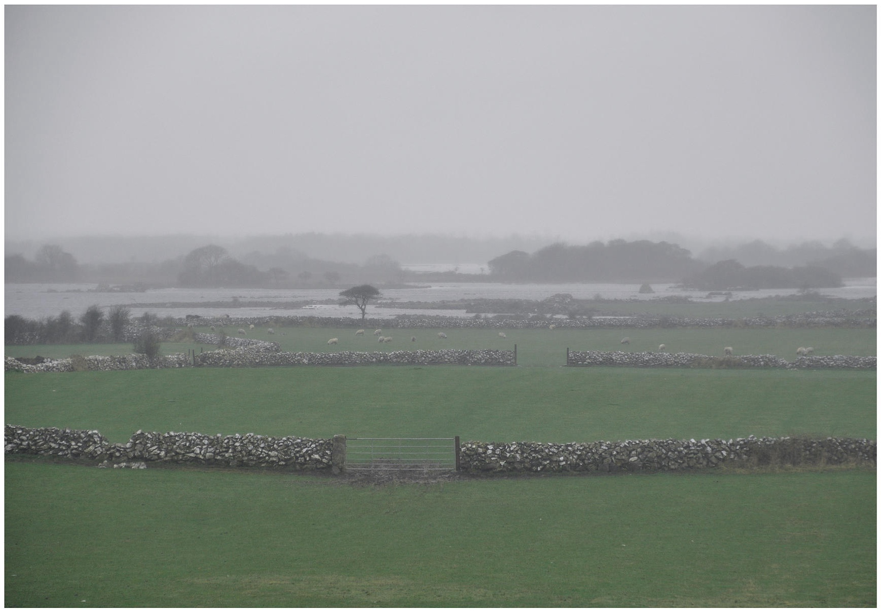
Despite the intensity and scale of the drawings created, only fragments of the original settlement remain. Almost all of the traditional dwellings have been demolished, due to a combination of economic modernisation, state rationalisation, post-famine depopulation, and the rise of individualised dwelling patterns. This has resulted in a landscape reshaped by the dominance of the car as a mode of transport and a post-war social movement that encouraged the construction of independent family homes.[30] Yet the drawings preserve a layered cultural memory that resists total erasure. They demonstrate that architecture is never fully apprehended through objects alone, but via the accumulated practices and narratives that inhabit them. The remaining structures that emerged as part of the vernacular tradition now exist in a continuum of that settlement morphology; the built environment is understood as a continuous field of collective thought.
Notes
- The title of this essay is derived from J.B. Harley’s essay ‘Maps, Knowledge, and Power’, in The Iconography of Landscape: Essays on the Symbolic Representation, Design, and Use of Past Environments (Cambridge: Cambridge University Press, 1988), 284.
A clachan, or hamlet, describes a settlement of clustered dwellings, arranged in an informal way and associated with a communal farming or rundale system. Typically found in Ireland and Scotland. See: Lindsay Johnston, ‘In Search of the Clachán’, in Architectural Association of Ireland, 16 (2007), 10–15. - Myles Dungan, ‘The Ordnance Survey in Ireland’, The History Show, 2025,<https://open.spotify.com/episode/5kq5WoSA9yGvpI0YfJ9U9c?si=Yv_Pr-QATBC3MP33aF0rxA> [accessed 31 December 2025]. It would take almost 15 years for the surveyors to reach Galway.
- Angèle Smith, ‘Mapped Landscapes: The Politics of Metaphor, Knowledge, and Representation on Nineteenth Century Irish Ordnance Survey Maps’, in Historical Archaeology, 41.1 (2007), 81–91.
- J.B. Harley, ‘Maps, Knowledge, and Power’, 277–312.
- Ibid.
- Smith, ‘Mapped Landscapes: The Politics of Metaphor, Knowledge, and Representation on Nineteenth Century Irish Ordnance Survey Maps’.
- Ibid.
- Caesar Otway, A Tour in Connaught: Comprising Sketches of Clonmacnoise, Joyce Country, and Achill (Wallingford: Sothis Press, 2023), 353.
- J.B. Harley, ‘Maps, Knowledge, and Power’, 277–312.
- Willy Cumming, ‘Traditional Houses from the Irish Folklife Architectural Drawing Collection’, Buildings of Ireland, 2016,<https://www.buildingsofireland.ie/building-of-the-month/traditional-houses-from-the-irish-folklife-architectural-drawing-collection/> [accessed 8 January 2026].
- Andrew Clancy, ‘The Casual Buttress: Certainty and Contingency in the Study of the Vernacular’, in Architectural Research Quarterly, 17.1 (2013), 92–96.
- Patrick Tuite, Material Culture Survey: Report on Materials, Construction and Cottages (Dublin: National Museum of Ireland, 1945).
- Clancy, ‘The Casual Buttress: Certainty and Contingency in the Study of the Vernacular’, 92–96.
- Ibid.
- Patrick Tuite, Material Culture Survey: Report on Materials, Construction and Cottages (Dublin: National Museum of Ireland, 1945).
- Andrew Clancy, ‘The Casual Buttress: Certainty and Contingency in the Study of the Vernacular’, 92–96.
- Barry O’Reilly, ‘“A Shower from the Sky”: Legitimating the Traditional Hamlet in Ireland’, in Traditional Dwellings and Settlements Review, 29.2 (2018), 23–38.
- Emyr Estyn Evans, Irish Folk Ways (London: Routledge & Paul, 1957).
- Tuite, Material Culture Survey: Report on Materials, Construction and Cottages.
- Clancy, ‘The Casual Buttress: Certainty and Contingency in the Study of the Vernacular’, 92–96.
- Tom Cookson, ‘Tim Robinson: Deep Mapping’, Drawing Matter, 2024,<https://drawingmatter.org/deep-mapping/> [accessed 7 January 2026].
- Tom Emerson, ‘Studio Tom Emerson – a Town Tormented by the Sea’, 2012, <https://www.emerson.arch.ethz.ch/design-studio/a-town-tormented-by-the-sea> [accessed 6 January 2026].
- Ibid.
- Peadar O’Dowd, ‘An Chrois: A Recently Restored Menlo Monument’, in Journal of the Galway Archaeological and Historical Society, 47 (1995), 216–20.
- Tom Emerson, ‘Studio Tom Emerson – a Town Tormented by the Sea’.
- Ibid.
- Ibid.
- Robin Evans, Translations from Drawing to Building (Cambridge, Mass.: MIT Press, 1997).
- Angèle Smith, ‘Mapped Landscapes: The Politics of Metaphor, Knowledge, and Representation on Nineteenth-Century Irish Ordnance Survey Maps’, Historical Archaeology, 41.1 (2007), 81–91.
- Johnston, ‘In Search of the Clachán’, 10–15.
*
Conor Lawless is an architectural designer and writer, based in London. His work explores how drawings shape our perceptions and understanding of the built environment.
