Cartography of a Wound
How do you draw a diamond mine? How do you depict a wound on the terrain, a spiral of extraction so powerful that it reorganises entire territories? On the sheet, the mine becomes a self-contained world—a floating territory of pits, conveyor belts, processing sheds, and housing blocks—but it also acts as a diagram of how regional authority is captured and reorganised around extraction. The drawing compresses many mines into one composite: a fictional complex whose influence spills far beyond its perimeter, binding distant decisions to the geometry of a single pit.
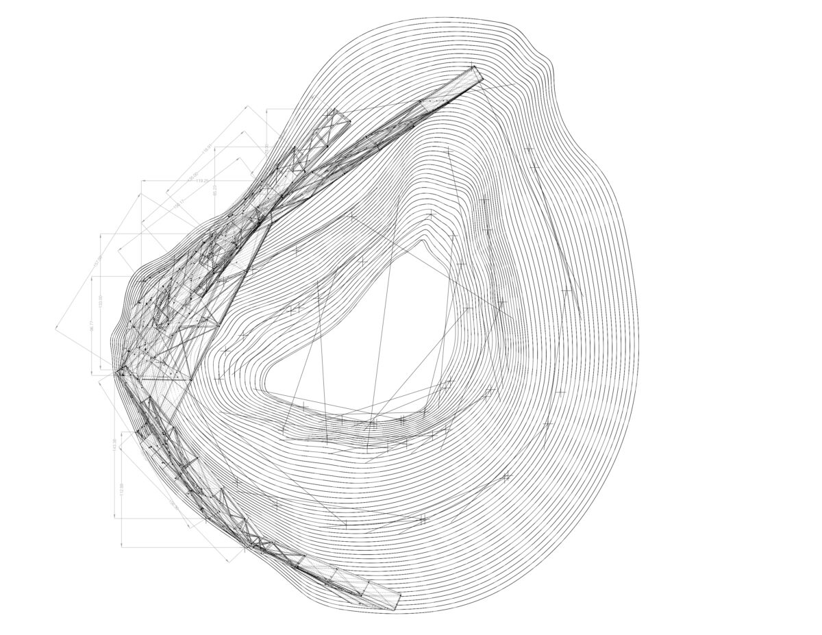
Cartography of a Wound: Plan Study, 2024. Composite plan of a fictional diamond mine, layering pit geometry and territorial infrastructure. Digital drawing, Rhinoceros 3D and AutoCAD. Courtesy of the author. 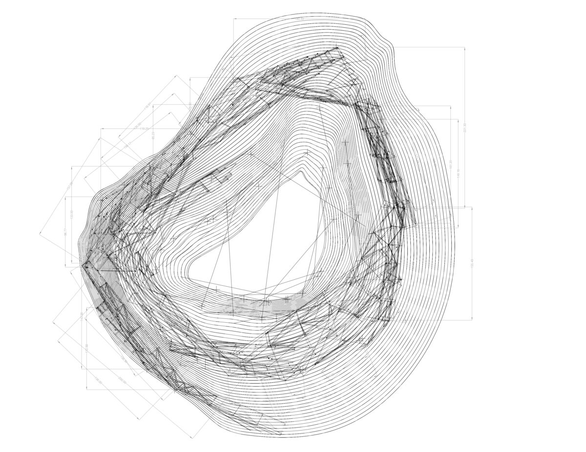
Cartography of a Wound: Plan Study, 2024. Composite plan of a fictional diamond mine, layering pit geometry and territorial infrastructure. Digital drawing, Rhinoceros 3D and AutoCAD. Courtesy of the author. 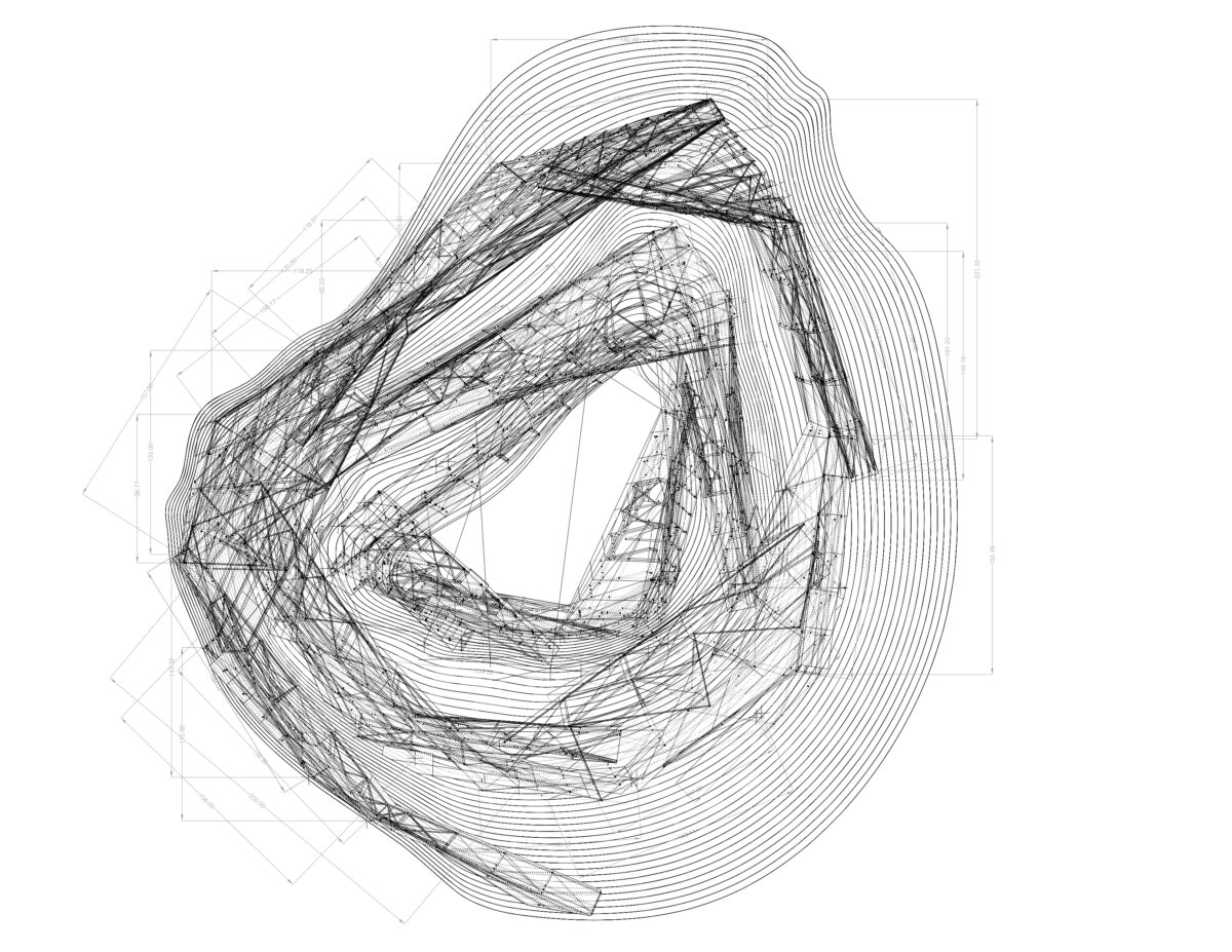
Cartography of a Wound: Plan Study, 2024. Composite plan of a fictional diamond mine, layering pit geometry and territorial infrastructure. Digital drawing, Rhinoceros 3D and AutoCAD. Courtesy of the author.
To begin such a drawing, the concession boundary is drawn as an architectural limit line. I drew a hard perimeter, a quasi-fortress edge separating the mine’s internal world from the surrounding land, which appears only as a thin, indifferent band. Inside this line, every stroke submits to the logic of extraction: roads that never reach a town, landing strips pointing toward elsewhere, pipelines and cables running in disciplined diagonals. The drawing contains buildings, but they remain secondary. What organises the sheet is not architecture as shelter but architecture as instrument—a machinery of sorting, crushing, exporting, enclosing.
Because the most decisive actions of extraction occur beneath the surface, the drawing cuts open the ground and flattens it. Plan, section, and axonometric projections overlap so that the pit appears simultaneously as wound, diagram, and a volume. The ground becomes a layered cross-section: terraced steps descending, each band hinting at another geological stratum removed. The deeper the pit, the lighter the lines become, as though the drawing itself is losing the ability to hold on to what has been taken. Above this void, the processing plant is rendered with rigid orthogonality, a contrast that suggests how tightly choreographed the industrial surface must be to sustain the disorder it produces elsewhere.
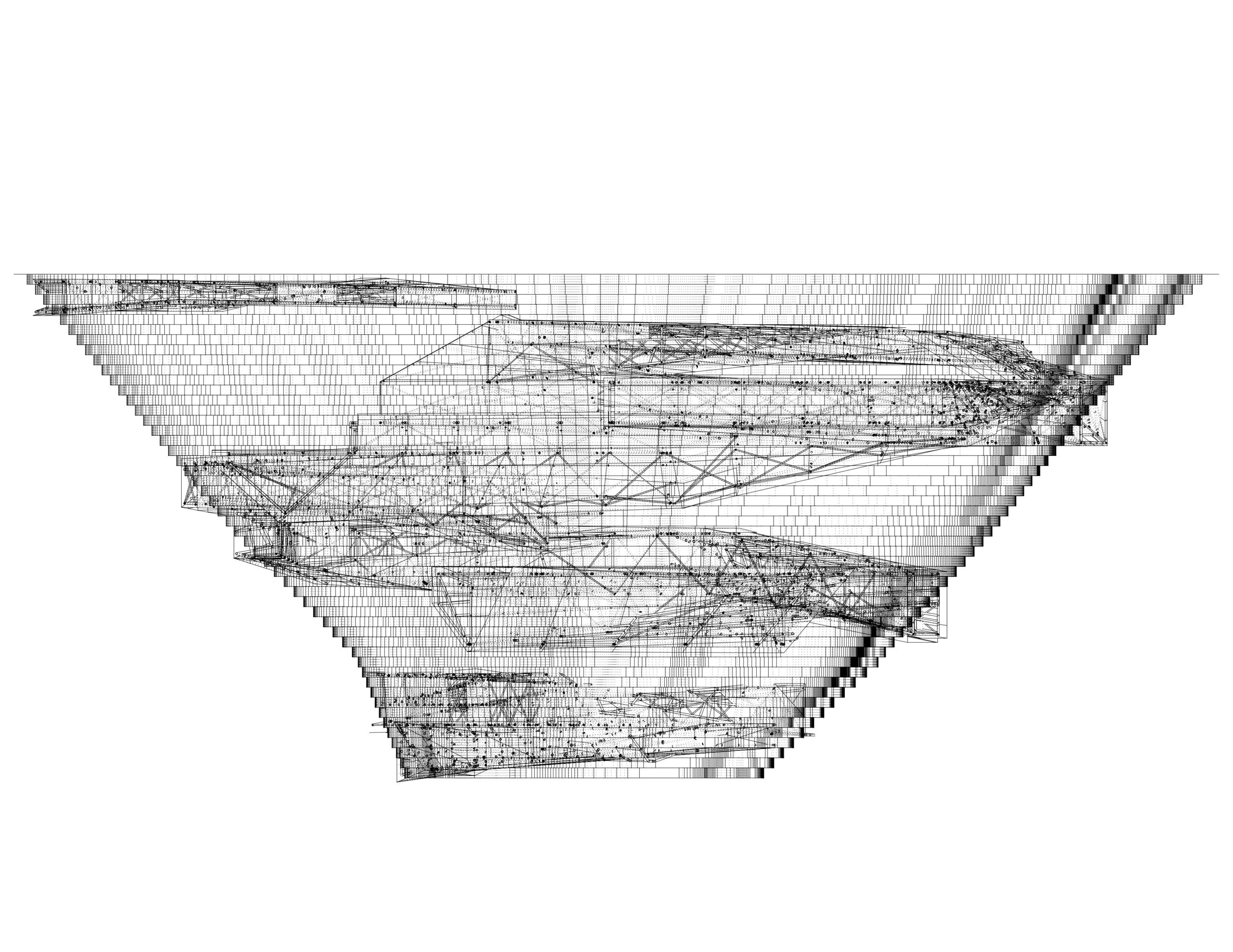
The drawing registers political pressure without collapsing into propaganda. The companies I studied do not need overt symbolism; their power resides in contracts, dependencies, and the quiet re-routing of infrastructure. To translate this into drawing, repetition becomes a measure of control. Fences, pylons, conveyor trusses appear again and again, each slightly shifted or thickened. Together they form a grid aligned not with civic planning but with the flows of ore, energy, and profit. Their consistency on the page reflects the uniformity of agreements that cannot be easily undone.
The drawing process was slow. I began with loose, tentative lines, imagining the edge of a pit or the sweep of a service road. Instead of erasing, I traced over missteps, allowing the ‘wrong’ trajectories to ghost beneath sharper iterations. These buried marks form a small archaeology of decisions—routes that might have connected the mine to existing settlements, patterns of occupation abandoned in favour of efficiency. The drawing holds the alternatives that were quietly discarded.
The drawing renders a method for thinking about what extraction does to territory. Scale is implied through a staircase here, the structure of a building there, but people are absent. This absence is deliberate and uneasy. It acknowledges a larger problem: the risk that imagery of extraction becomes elegant, smoothing over the violence it seeks to address. To counter this, I left certain parts unresolved. Some buildings remain hollow outlines; service lines trail off the sheet without destination. These unfinished zones admit the limits of representation: there are lives, negotiations, and losses the drawing cannot faithfully contain.
What the drawing can do is stabilise relationships that are otherwise diffuse. It ties the depth of the pit to the height of a watchtower; aligns the span of a conveyor belt with the length of a runway; compresses the distance between an administration block and a distant capital where decisions are made. By assembling these elements into a single frame, the drawing insists that they belong to the same system, even when separated in reality by thousands of kilometres and layers of bureaucracy.
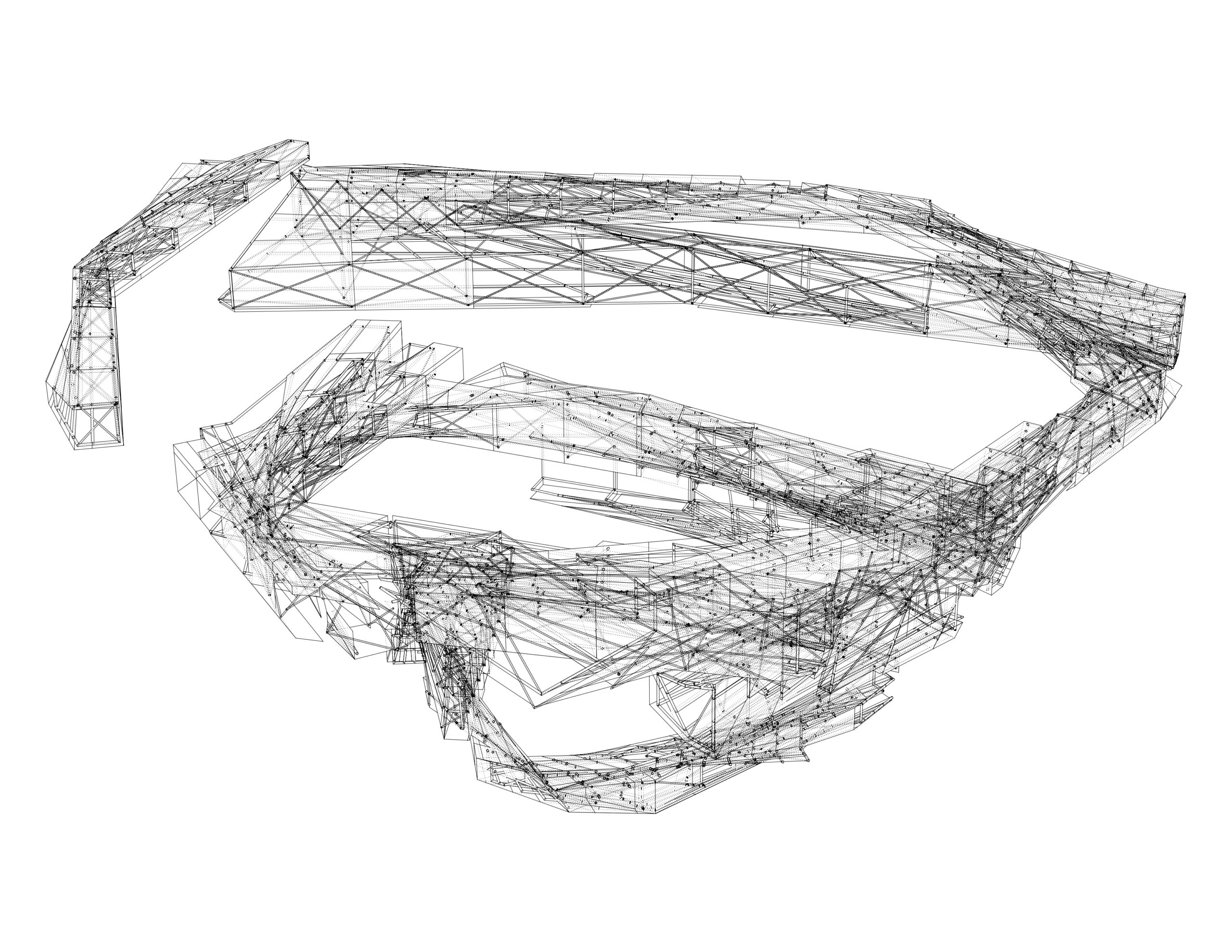
In this sense, the mine becomes part of the ‘unseen’ drawings of practice: not a presentation piece or technical document, but a private map of entanglements. It traces connections that remain hidden in corporate diagrams and official maps. If public visibility is often equated with exposure, this drawing proposes another mode of visibility: slow, analytic, incomplete. It does not pretend to reveal every facet of extraction or speak on behalf of those who live with its consequences. Instead, it uses the tools of architectural representation—projection, section, repetition, shifts in line weight—to outline a regime that thrives on abstraction, couched in figures of investment, employment, national growth. The mine on paper condenses those abstractions back to the scale of metres, steps, and walls.
In practice, drawings like this rarely leave the studio. They remain pinned above the desk, acting as provocations rather than deliverables—speculative sheets, strange axonometrics, overworked plans that continue to whisper questions long after a project has moved on. For me, this drawing asks how architecture might account for the spaces it sets in motion but does not directly design: the shafts bored into the ground, the contracts negotiated across borders, the decisions taken in distant offices. It asks what it means to draw infrastructures that organise territory while seeking to remain invisible.
To draw the mine is to accept that the unseen is not outside architecture but folded into its lines. The drawing becomes a way to hold: the wound in the terrain and the city suspended over a void.
*
Laura del Pino is an architect, educator, and researcher, currently an Adjunct Professor of Architecture at NYIT and at Kean University’s School of Public Architecture, following fourteen years as a Senior Design Associate at CAZA Architects. She holds an MSc in Advanced Architectural Design from Columbia GSAPP and bachelor’s and master’s degrees from the University of Valladolid. Her writing has appeared in COTAA Journal, Urban Omnibus, and Desired Landscapes.
This text is one of the selected responses to the second category of the Open Call 2025: Visibility, and the Unseen—a series of short contributions that either bring to the surface the unseen drawings within the Drawing Matter Collection (I. In the Archive) or explore original architectural drawings, created by the author(s) of the contribution, which make visible the unseen (II. In Practice).
