DMJ – The Stereoautograph
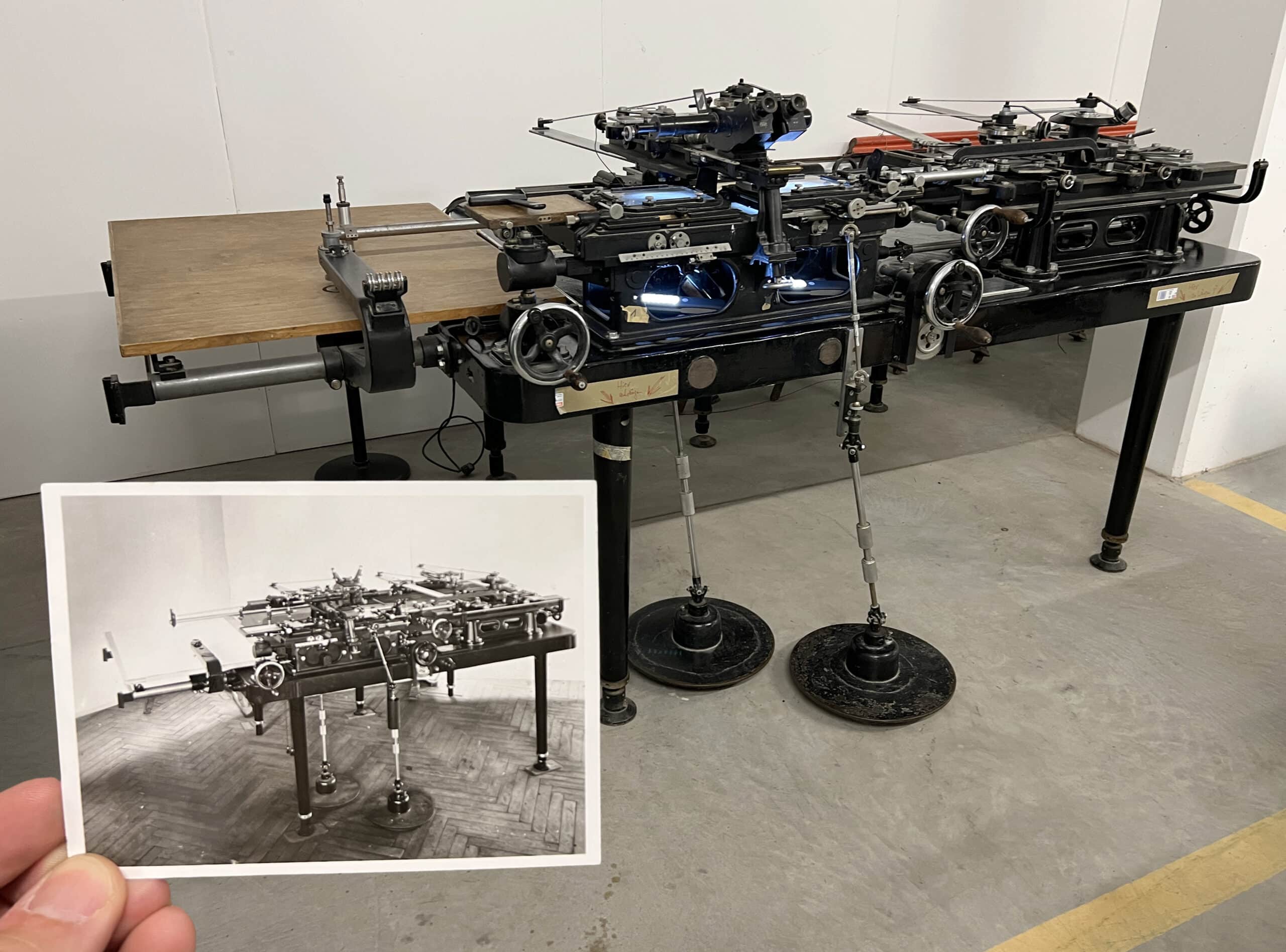
The Zeiss Stereoautograph 1914 Bild II is a mammoth device (Fig.1). It weighs over 400kg and has the same footprint as a Smart Car. When it was retired and donated to the Zeiss Archive in 2004, the Technical University of Hanover had to remove part of its roof in order to lift it out by crane. In the era of GPS and Google Maps, it sounds unimpressive to say ‘This machine draws maps’—but when it was developed in 1908, the stereoautograph was hailed as a singular achievement in cartography and a triumph of photogrammetry.[1] For the first time, a cartographer could draw precise maps without labour-intensive field surveys. The stereoautograph’s extraordinary claim was that it was able to turn photographs into topographic drawings.
Throughout the late 19th-century spread of photography, photogrammetry’s goal of plotting maps from pictures contained much promise. The entire process is predicated on a simple geometric question: how do you turn a photograph’s implied Z-axis—the apparent depth recorded in it—into the scaled elevational contours of a map? Can you extract measurements from a photo and convert that information into graphical planimetric data?
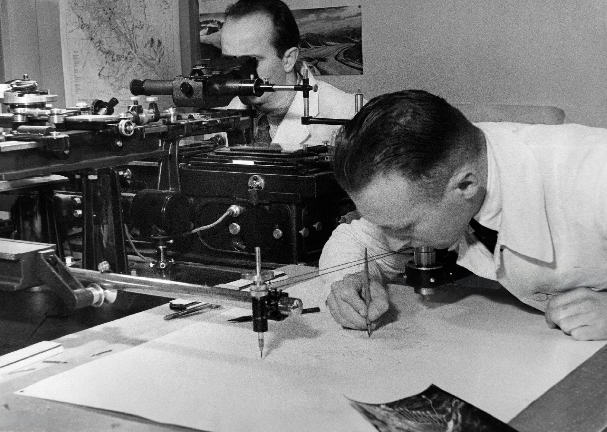
As an architect trained in the pre-digital era, I have done the reverse of this many times. I know how to use orthographic drawings—plans and sections—to construct a perspectival image. But the geometry works both ways: it is also possible to reverse-engineer plans and sections from linear perspective drawings. Amazingly, the stereoautograph does this without calculations or drafted construction lines. Archival photos depict an operator looking into a binocular eyepiece while turning hand cranks. The complex array of linkages and carriage slides somehow results in a contour drawing of incredible precision.
To better understand how the stereoautograph works, I went to the Zeiss Archive in Jena, Germany. The machine had not been touched since it arrived from Hanover two decades earlier, and I spent several days restoring it to working condition, eager to try this drawing process.[2] But to comprehend the operating mechanics of the stereoautograph, we first have to recognise the mathematical and technological innovations that preceded it.
The underlying principles of photogrammetry were developed through efforts by Albrecht Meydenbauer in Germany, Aimé Laussedat in France, Édouard-Gaston Deville in Canada, and others from the 1850s until 1900.[3] Mathematically sound but laborious and often impractical, early photogrammetry required careful calculation to extract precise three-dimensional coordinates. This process was tedious and error-prone, even when using the most detailed photographs and especially when mapping complex terrain. Photogrammetry leapt forward when Carl Pulfrich, a Zeiss optical factory researcher, proposed using stereophotography to extract distance data.[4]
When you look at a pair of stereoscopic images, the apparent depth of an object is a function of the baseline shift, or ‘parallax’, between the pairs. Nearby objects have a significant baseline shift; distant objects shift very little. This mimics human optical ‘vergence’—the rotation of the eyes in our binocular vision system. To look at your outstretched hand, your eyes rotate towards each other (convergence); to shift focus towards a distant mountain peak, your eyes rotate away from each other (divergence). Part of our mental image of depth comes from this physiological process. We instinctively know that the amount of eye crossing – the magnitude of parallax—tells us how far away something is. To measure the baseline shift between stereophotographs, Pulfrich invented the stereocomparator in 1901.
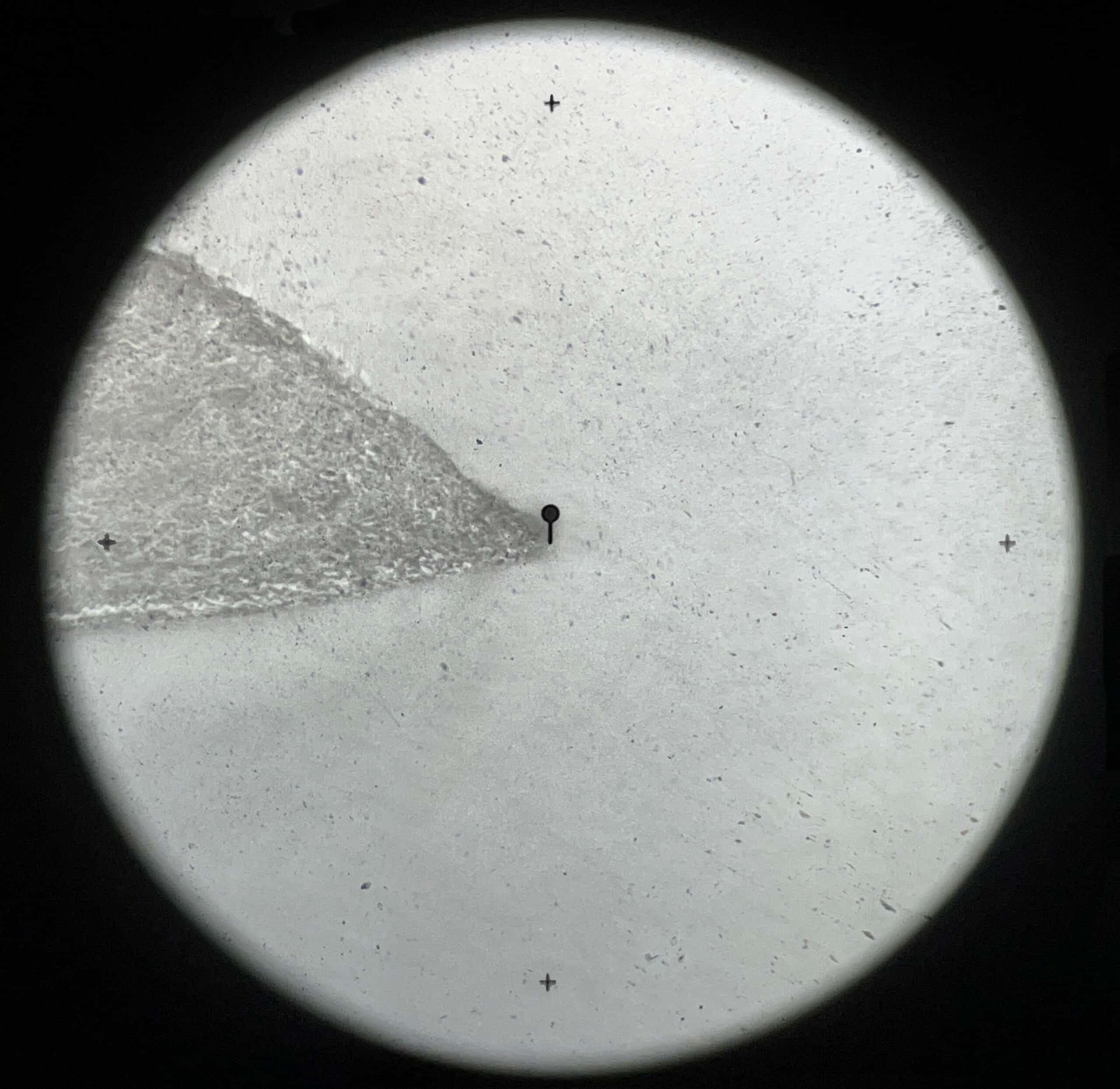
The stereocomparator is a binocular microscope mounted over a pair of glass plate stereoscopic photographs fixed to sliding carriages. Inside the eyepiece, the operator sees a small reticle at the centre (Fig.2). By operating hand cranks, the operator can move the photographs in unison in the X (horizontal) and Y (vertical) axes, making it appear that the reticle is ‘travelling’ across the image or up and down. A third crank controls the Z-axis, or travel distance between foreground and background. This carriage slide moves the stereopair closer or farther apart, making it seem as if the reticle is travelling nearer or farther away. The stereocomparator measures the Z-axis distance as a function of the parallax baseline shift, and because it is a microscope of 10x magnification, operators have a precision of 0.02mm. From this shift, trigonometric calculations can provide accurate distance measurements for any location within the photographs. By operating all three cranks to locate the reticle in the landscape, the operator can locate an X-Y-Z coordinate directly from stereoscopic photographs.
The Pulfrich stereocomparator launched a sub-discipline of photogrammetry: ‘stereophotogrammetry’. But it was still only a measuring device. It could read distances and coordinates accurately but still required an operator to do numerous calculations to produce even basic maps. The stereocomparator couldn’t draw. The magic, provided by the Austrian scientist Eduard von Orel, was to turn Pulfrich’s machine from a stereometric device to a stereographic one.
Von Orel’s stereoautograph integrated linkages and sliding carriages into the stereocomparator (Fig.3). Each stereocomparator movement by the operator, in the photograph’s X, Y, or Z directions, directly translated to a pencil moving on the drawing board, but only in the planimetric X and Y axes. Moving the reticle in the X direction moved the pencil in the X direction. Moving it in the photographic Z-axis (nearer or farther) moved the pencil in the map’s Y direction.
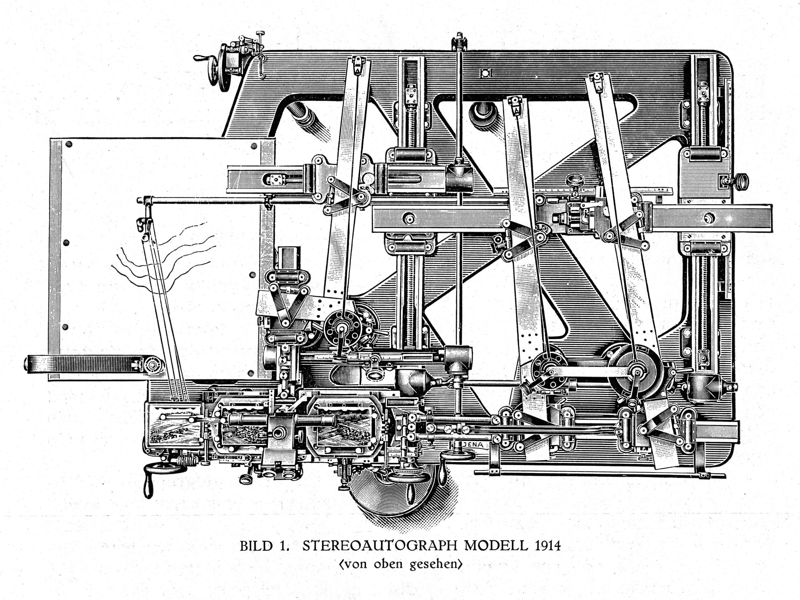
The operator’s job was to identify a specific point on the terrain and ‘take the reticle for a walk’ along that elevation, moving in, out, and across the image using a combination of hand cranks. The machine then automatically generated the contour line of that path through the coordinated trigonometrically aligned system of gears and hinges. Once that contour was complete, the operator moved to the next contour using the comparator’s Y-axis crank. Scaled rulers on each slide allowed the operator to create maps from 1:5000 to 1:50000 scale.
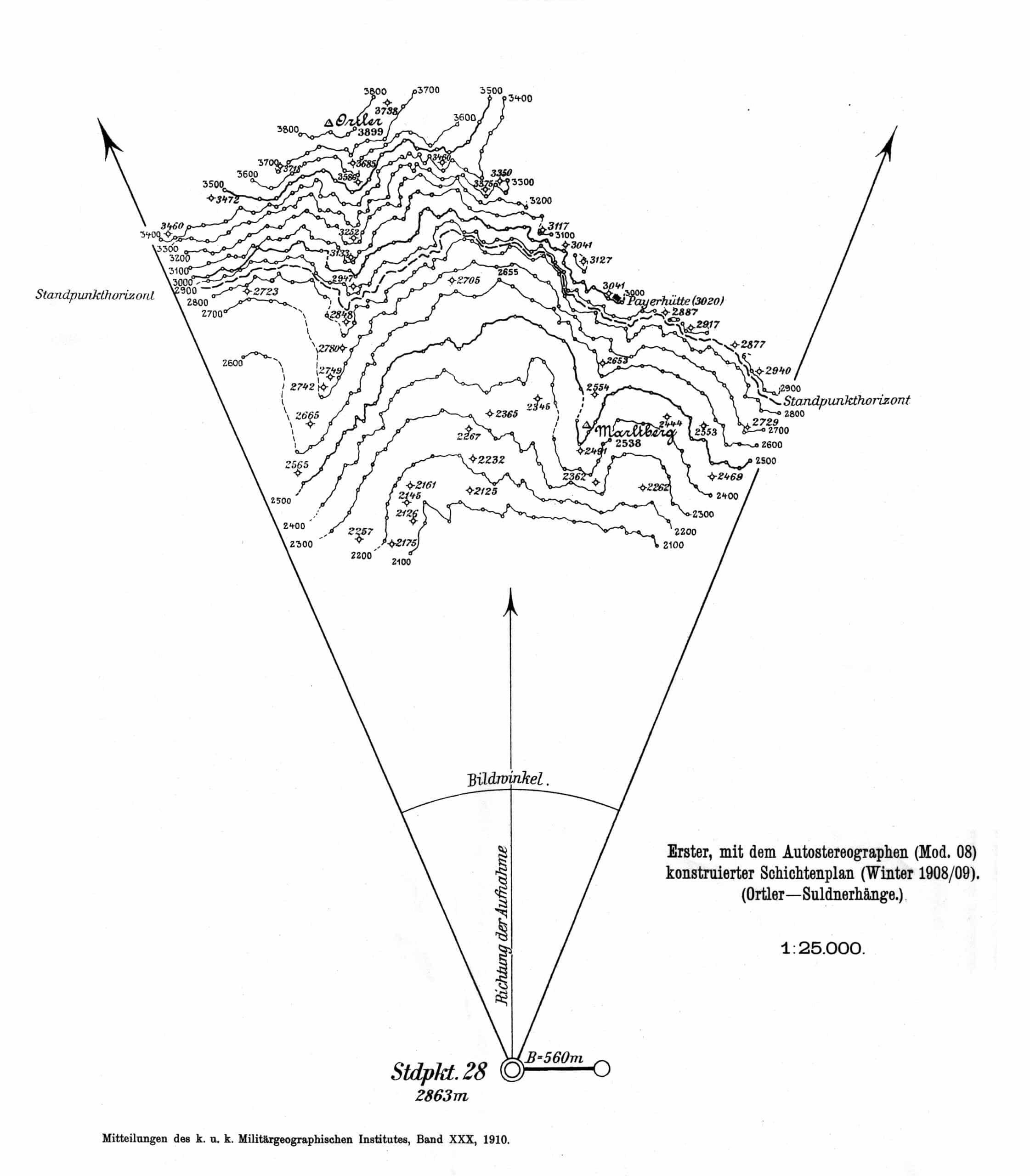
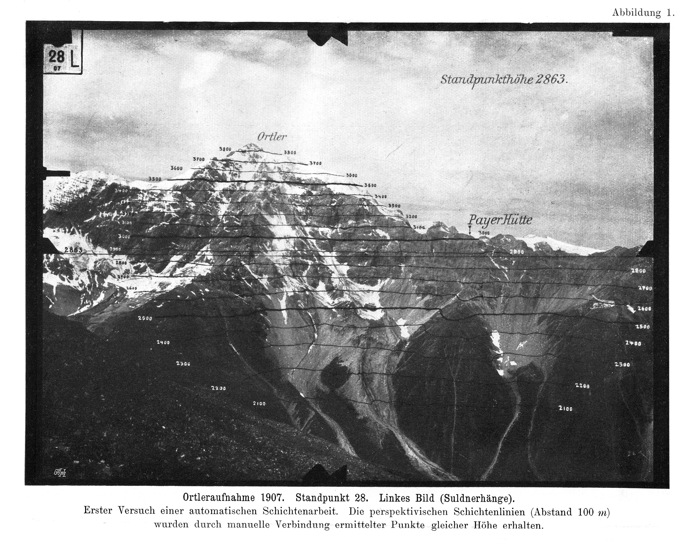
In 1908, to demonstrate his machine to his Austria-Hungary Military superiors, von Orel sent a team of surveyors with purpose-built stereoscopic cameras to photograph the Ortler peak in the Tyrol, Austria.[5] They took basic tachymetric surveying measurements and photographed the peak from across several valleys to obtain views from different angles. His first drawing, made from a single viewpoint, shows the system at work. The Standpunkt is the station point, where the camera stood. The field of view is a triangle—the plan view of the cone of vision (Fig.4).
However, to produce a complete map of a region, the operator was required to use multiple stereopairs to observe the terrain from different vantage points. The von Orel team photographed the peak with overlapping fields of view to produce the first stereoautographic map, delivering on the promise of photogrammetry proposed nearly a half-century earlier.
The stereoautograph also automatically generated a reference composite image while drawing the topographic map. If the operator mounted a positive print alongside the left-hand negative, a pen attached to the stereocomparator would also generate a ‘terraced’ contour overlay as the reticle travelled across the terrain. This quick data visualisation was both useful as a legend for the drawn contour map and as a proof-of-concept image confirming the precision of the stereoautograph (Fig.5).
Von Orel’s achievement was short-lived. Even though Zeiss effectively invented the stereoautograph market, aerial stereophotogrammetry had begun to supersede the Zeiss-von Orel terrestrial system by the early 1920s. Gyroscopic mounts and finely calibrated cameras produced by Zeiss —a project consolidated in the subsidiary Zeiss Aerotopograph in 1921—began efficiently capturing terrain from above. The stereoautograph was simplified. Instead of converting baseline parallax into terrestrial distance, aerial stereophotographs used vergence to measure topological height variations. The stereocomparator no longer answered the question ‘How far away is that?’—it now determined ‘How high is that?’
No doubt this was a necessary efficiency to produce better maps and sell more devices, but the architect in me laments what is lost in that 90º reorientation. When you extract a plan from a view, you explore centuries-old spatial representation conventions through drawing. When you make a map from an aerial photograph, you convert a plan into a slightly better plan.
But the advent of aerial stereophotogrammetry wasn’t the end of von Orel’s invention. The stereoautograph’s finest hour was still to come. The machine’s especially precise mechanics were best suited to mapping mountainous terrain, where dramatic elevation changes proved challenging for conventional surveying techniques. Weimar Germany’s fascination with images of heroic mountaineers [6] set the stage for some of the most ambitious automated drawing projects ever attempted.
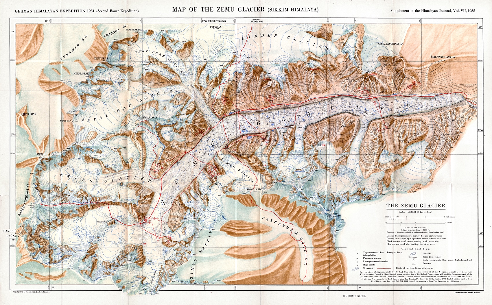
The 1931 German Himalayan Expedition set out to conquer the Kanchenjunga peak in Sikkim, India. No one had yet successfully climbed this mountain—the third highest in the world. Geologists, glaciologists and cartographers joined the team to study the remote territory, focusing on the Zemu Glacier that sits in the shadow of the formidable mass. Dr Richard Finsterwalder, the lead cartographer for the expedition, observed, ‘[Aerial photogrammetry] was impracticable, not only because of expense but also owing to the difficulty of flying high enough above the objective, itself over 8,500 metres.’[7] He made a case for taking terrestrial stereophotographs to produce new maps on von Orel’s stereoautograph (Fig.6). Between July and October 1931, the photographic team captured 195 pairs of stereoscopic images from ten groups of bases on both sides of the 26-kilometre glacier. Finsterwalder utilised 51 pairs of photographs to draw the entire Zemu Glacier and Kanchenjunga in five weeks (Figs 7, 8, 9).[8]
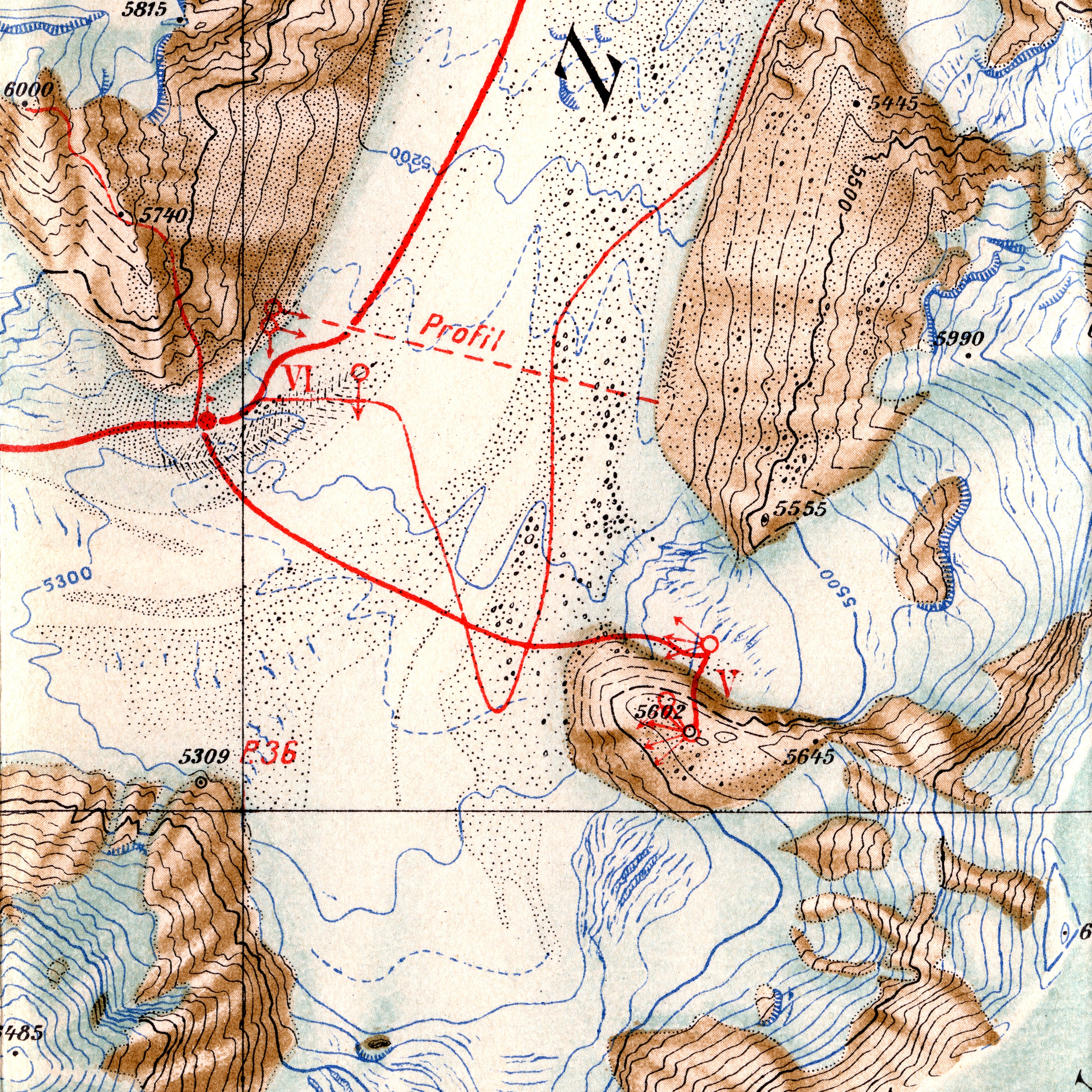
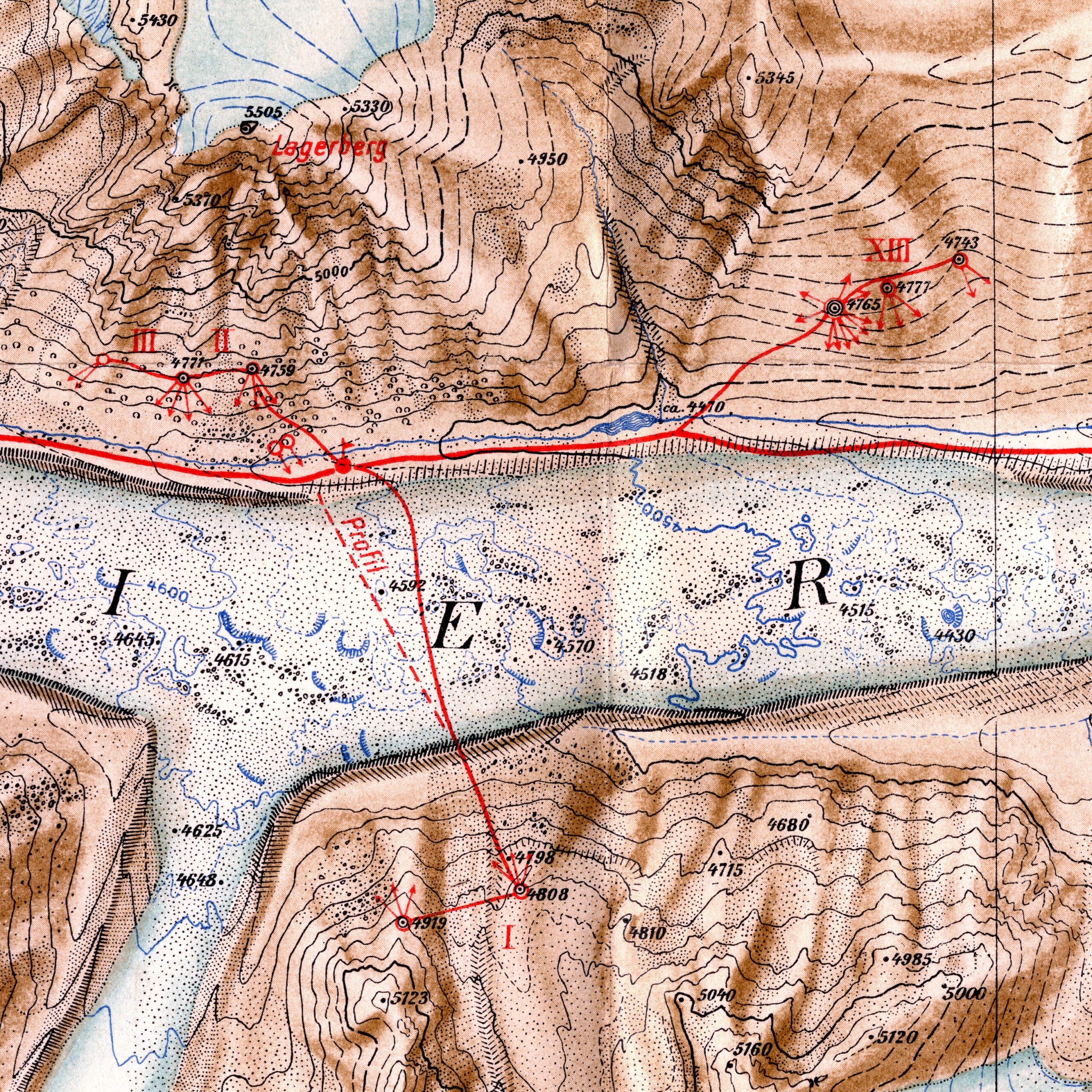
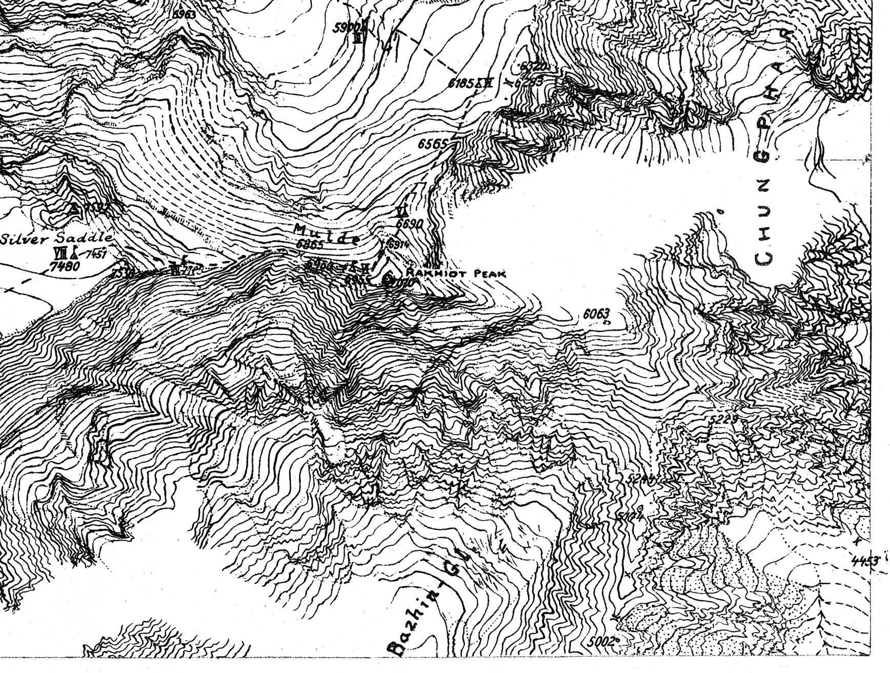
Publishing a highly detailed map and comprehensive account in English announced a triumph for German cartography, and served as a victory lap for von Orel’s ‘obsolete’ terrestrial stereoautograph. In the same journal, Finsterwalder shared a rare glimpse of a different map in progress. In 1934, he joined the ill-fated German Expedition that failed to surmount the extremely treacherous Nanga Parbat peak, in which nine German scientists and six Sherpas were killed. His ambition was to make the largest stereoautographic map ever attempted of mountainous terrain, personally photographing over 1,000 square miles of the Western Himalayan territory. Alongside a tribute to his fallen colleagues, he shared a reproduction of a small section of the machine-drawn stereoautographic map, drawn by his protégé Hans Biersack.
The drawing is a dizzying array of dense contour lines with handwritten notes, small corrections and incomplete areas—a true process drawing (Figs 10, 11). Unlike the printed Zemu Glacier map, this drawing does not identify camera locations or other expedition data, but it has smudges, broken lines and tiny hesitations. These hallmarks of a manual drawing imbue this mechanical process with a sense of time. Every change of line direction relates to the way the mechanism was manipulated in a deliberate, coordinated manner by Biersack’s hands. The drawing reveals this process as a physically intensive, durational performance extended across hundreds of hours. Each line is a slow walk along a slope, a careful path executed through a unique human-machine collaboration.
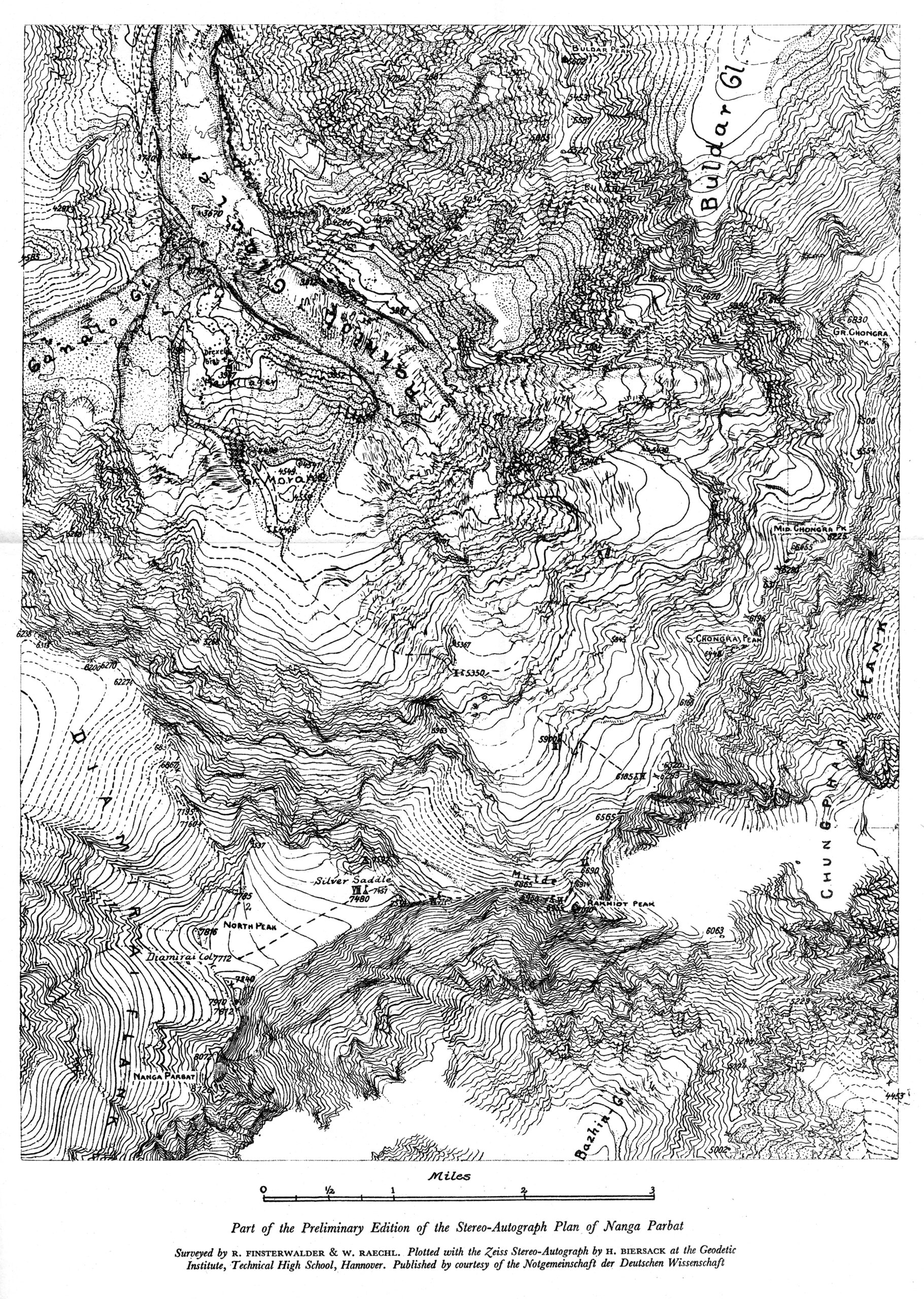
While I managed to restore the Stereoautograph 1914 Bild II mechanics, I could not calibrate the delicate stereocomparator lens array to precisely generate a drawing from the pair of stereophotographs. The journey from Hanover, through the roof and on a truck, caused misalignments within the stereocomparator’s sealed optical system. I could move the stylus as Finsterwalder, Biersack and other stereoautographers did, but it was not aligned with the photographic terrain. It was still a worthwhile investigation of a forgotten machine, one filled with history and wonder. I value the opportunity to draw in obsolete and forgotten ways; there is much to learn about drawing from walking in the footsteps of past draftspersons. And this—it turns out in this case to be literally true. The provenance of the stereoautograph in the Zeiss holdings confirmed that not only did von Orel oversee the construction of this machine sent to Hanover, but documents also reveal that Finsterwalder and Biersack produced the Nanga Parbat map on it. Although it may be tucked away in an anonymous warehouse in central Germany, it has an importance for drawing history that outweighs even its colossal mass.
Notes
- Arthur Hinks, ‘Stereographic Survey: The Stereoautograph’, The Geographical Journal, vol.59, no.4 (Apr. 1922), 273–284.
- I am indebted to Zeiss Archive Director Dr Wolfgang Wimmer and Dr Jürgen Hellwig for their generous hospitality in July 2023, including granting access to the Stereoautograph and invaluable documents within the Zeiss company files.
- For a contemporary account of the state of the Photogrammetry field in the early 1900s, see Max Weiss, Die geschichtliche Entwicklung der Photogrammetrie und die Begründung ihrer Verwendbarkeit für Meß- und Konstruktionszwecke (Stuttgart: Strecker & Schröder, 1913).
- To share his discoveries, Pulfrich launched the Ferienkurs in Photogrammetrie (Vacation Course in Photogrammetry) in 1910, continuing these workshops until the outbreak of World War I. For these efforts, he is sometimes called the ‘father of stereophotogrammetry’. See Dieter Fritsch, ‘The Photogrammetric Week Series – A Centennial Success Story’, in Photogrammetric Week 5 (Heidelberg: Verlag, 2005), 4–6.
- Von Orel produced a report published in 1910 in Mitteilungen des k. u. k. Militärgeographischen Institutes, Band XXX (‘Messages from the Imperial and Royal Military Geographical Institutes, vol. XXX’).
- Famed mountaineer Paul Bauer is credited with casting his German expeditions to the Himalayas between the wars as a way to ‘utilize the experiences generated by German mountaineers under great sacrifices for the well-being of the German Volk’. See Harald Höbusch, Mountain of Destiny: Nanga Parbat and Its Path into the German Imagination (Rochester: Camden House, 2016), 37. This book provides an important historical appraisal of Bauer and the German fascination with treacherous mountain climbing in this era.
- Richard Finsterwalder, ‘On the map of the Zemu Glacier’, The Himalayan Journal: Records of the Himalayan Club, VII (1935), 125.
- An exhaustive account of this scientific and cartographic enterprise was published across several articles in The Himalayan Journal: Records of the Himalayan Club, VII (1935).
Pablo Garcia is Associate Professor in the Department of Contemporary Practices at the School of the Art Institute of Chicago. Trained as an architect, Pablo’s recent work has evolved from design-for-hire to internationally exhibited artworks, provocations and research studies. Previously, Pablo has taught at Carnegie Mellon University, Parsons School of Design, and The University of Michigan. From 2004-2007, he also worked as an architect and designer for Diller Scofidio + Renfro. He holds architecture degrees from Cornell and Princeton Universities.
The article is included in the second issue of DMJournal, Drawing Instruments: Instrumental Drawings.
